Measurements of sea-level rise from melting ice get even more accurate
DOI: 10.1063/pt.upgx.bvjw

Earth’s sea level has been rising at an average of about 3 mm/year since satellite altimetry measurements began in 1993. Most of the change is attributable to ice on land melting into the ocean, which increases barystatic sea level. (The thermal expansion of water is the other cause of sea-level rise.) But because of limitations in ocean-observing networks, estimates of barystatic sea level have included large uncertainties. (See the article by Bruce Douglas and Richard Peltier, Physics Today, March 2002, page 35 .)

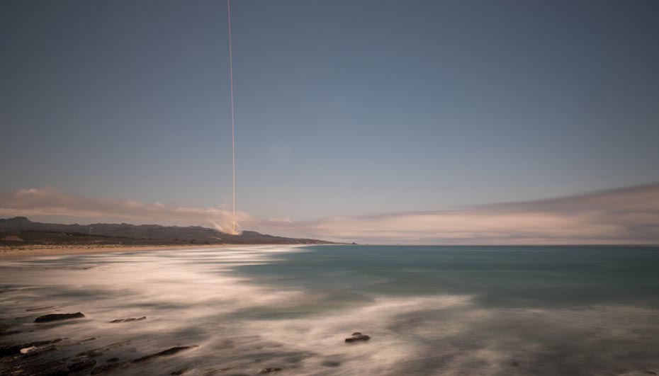
This long-exposure photo shows the 22 May 2018 launch of NASA’s GRACE-FO, a mission that continues the work of its predecessor, GRACE, to better understand how mass is distributed in Earth’s atmosphere, oceans, and ice sheets. (Photo by NASA/Bill Ingalls.)
The situation improved in 2002 with the launch of NASA’s GRACE (Gravity Recovery and Climate Experiment) mission to provide, among other data, high-resolution measurements of barystatic sea level. But there’s still a one-year gap in observations between GRACE and its successor, GRACE-FO (Follow-On). In addition, one of the two accelerometers on each of the twin satellites suffered malfunctions, which have led some scientists to question the data’s reliability. Now Yufeng Nie and Jianli Chen (both with the Hong Kong Polytechnic University) and colleagues have used data from various satellites to make an accurate time series of barystatic sea level that goes back to 1993. Consistent with previous findings, their results show that the barystatic contribution is responsible for 1.9 mm/year of sea-level rise over the past three decades.
The pre-2002 data come from satellite laser ranging. The method measures sea level through gravity-field estimates, which are derived from the time it takes ultrashort pulses of light to travel from a satellite to the ground, then back to the satellite. In the past, the problem with satellite laser ranging has been the lack of spatial resolution. At about 4000 km, the resolution is suitable for researchers to resolve large-scale changes of entire ice sheets, for example, but is insufficient for them to accurately see what’s happening at the land–ocean boundary. The inaccurate measure leads to an underestimation of barystatic sea-level rise.
To address that problem, Nie and colleagues put their data into a gridded observational model that corrects for the uncertainty at the land–ocean boundary and thus gives more reliable estimates of long-term barystatic sea level. They find that since 1993, Greenland has contributed to a rise in barystatic sea level of 0.6 mm/year, which is about equal to the combined contribution of all other glaciers on Earth except for those in Antarctica. That result is similar to previous findings, but the independent approach offers a way to better constrain earlier estimates of sea-level rise. The new time series captures the acceleration in global sea-level rise too. Although the barystatic sea level since 1993 has increased by 1.9 mm/year, since 2003 it’s climbed to 2.2 mm/year. (Y. Nie et al., Proc. Natl. Acad. Sci. USA 122, e2425248122, 2025 .)
This article was originally published online on 10 July 2025.
More about the authors
Alex Lopatka, alopatka@aip.org


