Fault movement may affect erosion as far as 100 km away

Figure 1.

These rocks at the Vasquez Rocks Natural Area park in Southern California are the result of uplift caused by tectonic movement along the San Andreas Fault. In new work, researchers observed signs of fractured rock and high erosion rates in areas up to roughly 10 km from that fault.
(Photo by iStock.com/hmlCA.)

Crustal movement along fault lines sculpts the land by triggering earthquakes, reshaping rivers, and uplifting rocks, such as those shown in figure 1 . It’s well known that along with producing earthquakes that cause sudden damage through pulverization, active faults can gradually fracture and weaken rock that is up to a kilometer away. To better understand how far the tectonic damage may reach, Boontigan Kuhasubpasin (then at UCLA) and colleagues analyzed erosion rates at river basins worldwide. 1 They determined that erosional efficiency, a measure of how effectively eroding forces move material away, was elevated as far as 100 km from an active fault. The research team also proposed that repeated shaking from earthquakes compounded the effects over time, making rock more susceptible to geomorphological changes caused by weathering or landslides.
Unlike earthquakes, erosion takes place over millennia. To understand how a landscape changed over time, researchers can measure the concentration of the long-lasting isotope beryllium-10. Cosmic rays interacting with quartz near Earth’s surface produce in situ 10Be, which accumulates in the upper few meters of exposed rock. High 10Be concentrations indicate relatively slow erosion, whereas low concentrations suggest rapid removal of near-surface material by erosional processes. Kuhasubpasin and colleagues looked at more than 1700 10Be-derived erosion rates from across the globe and then analyzed potential sources of the erosion in those areas. The factors included mean annual precipitation, rock type, distance from active faults, and a measure of seismic shaking intensity called peak ground acceleration.
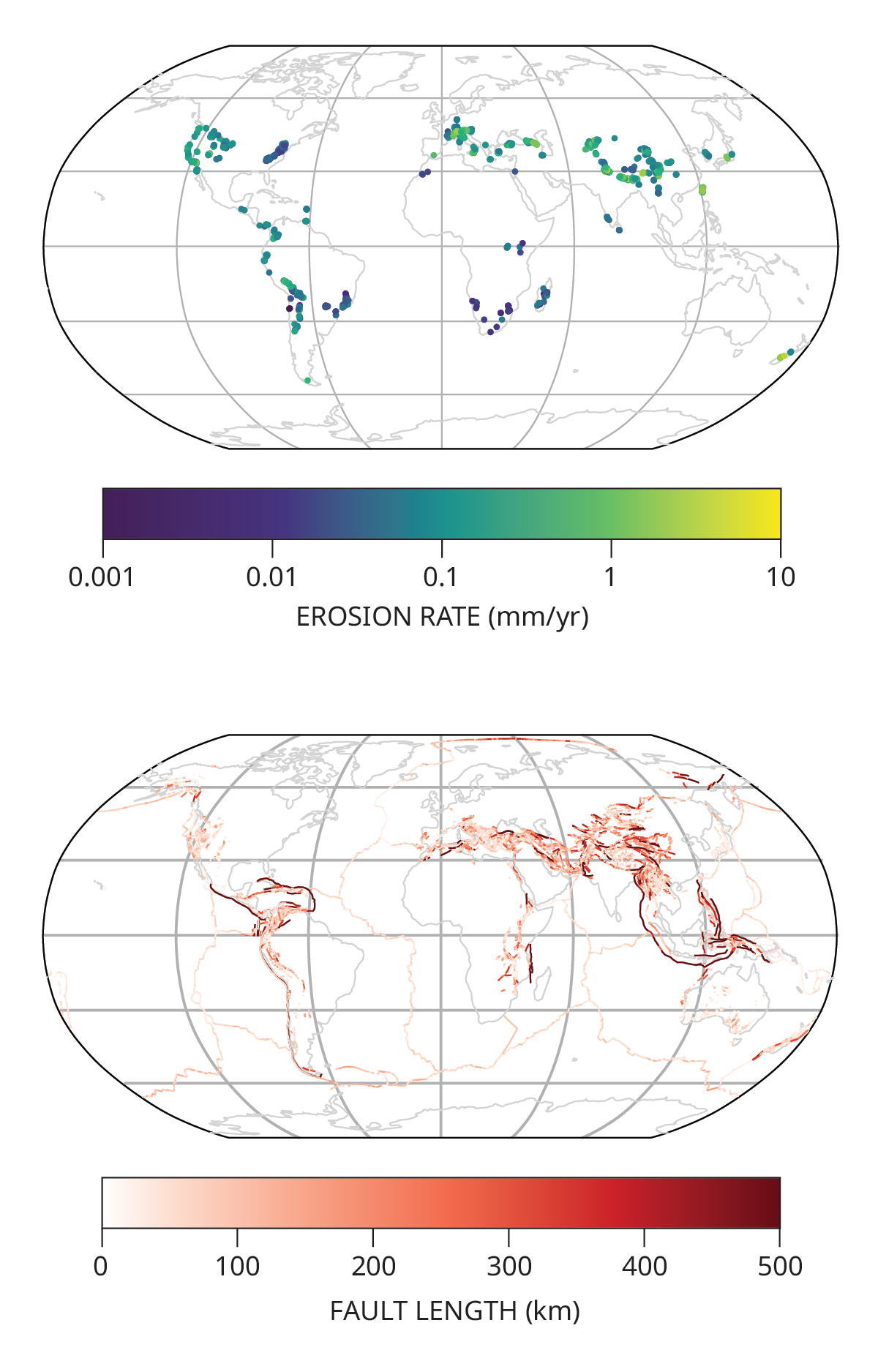
Figure 2.

Global maps of both the erosion rates calculated from concentrations of beryllium-10 at river basins (top) and the distribution of active faults (bottom). The highest rates of erosion are shown in yellow and green, and the longest faults are shown in dark red. Using statistical modeling and machine learning, the team compared the maps and found that distance from faults had more influence on erosion than did other potential factors.
(Figure adapted from ref. 1 .)

Using statistical and machine-learning models to evaluate the influence of those factors on erosion, the team found that the distance from an active fault was the primary predictor of erosional efficiency in the sampled area. Figure 2 illustrates that relationship. Erosional efficiency was at its highest up to 15 km away, and it was still elevated up to 100 km away. The team also found that the effects were strongest near large reverse faults, where rock that lies above the fault plane is forced up, and that there was a positive correlation between erosional efficiency and peak ground acceleration. To support their data analysis, the researchers analyzed previous field measurements taken near the San Andreas Fault in California. They observed signs of fractured rock and higher erosional efficiency in areas up to roughly 10 km from the fault, though not in areas beyond that distance.
The finding suggests that repeated exposure to seismic shaking can contribute to the weakening of surrounding rock by disrupting grain boundaries and expanding fracture networks. There are still uncertainties, including how grain-to-grain disturbances propagate through rock and influence sediment dynamics, that researchers can work to better understand, says Kuhasubpasin. Altogether, the work offers a new way for researchers to understand the role of tectonic damage in geomorphological change, especially in regions where it was previously underestimated.
Reference
1. B. Kuhasubpasin, S. Moon, C. Lithgow-Bertelloni, “Role of tectonic rock damage in erosional processes: A global analysis ,” Science 392, eady9857 (2026).