Rivers in the sky


Have you ever experienced several days in a row with gray skies, wind, and rain? If you live between the latitudes of 30° and 60° N or S, the chances are high that you were within an atmospheric river. At any given time, each hemisphere contains three to five atmospheric rivers, which form and dissipate on time scales of days to weeks. The long, narrow storm systems transport water vapor from the warm subtropics into the cooler midlatitudes, leading to prolonged periods of cloudy skies and precipitation and sometimes causing major flooding events.
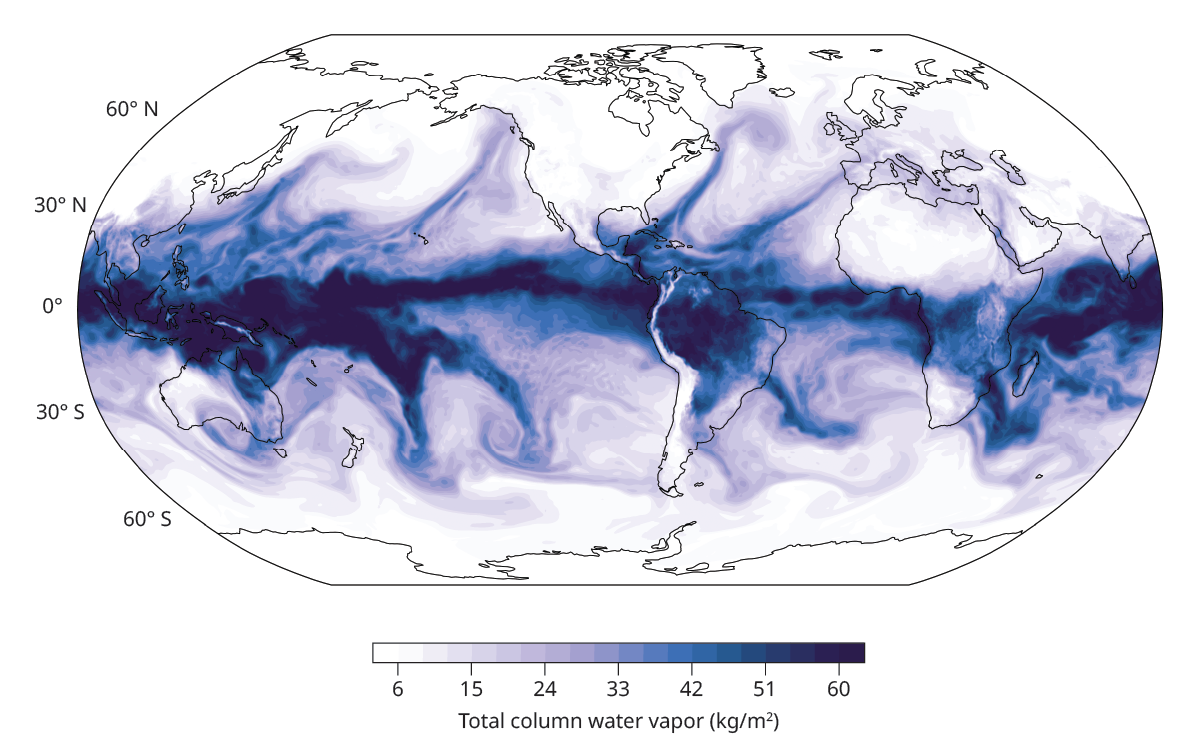
Though atmospheric rivers, shown in figure 1, are typically only a few hundred kilometers in width, they can stretch for thousands of kilometers in length, sometimes reaching across entire oceans. Since the features were first identified, they have been found to exert control over rainfall and water resources in many regions. They also play a major part in the distribution of water and energy across the globe, a role that may be changing and evolving as the climate warms.
Figure 1.

A global snapshot of the total column water vapor (the total mass of water vapor above a square meter) on 12 December 2023. The Northern Hemisphere contains four distinct atmospheric rivers: two in the North Pacific and two in the North Atlantic. In the Southern Hemisphere, atmospheric rivers over Australia and the South Pacific exhibit spiral structures that highlight the cyclonic motion around low-pressure systems, which flow clockwise in the Southern Hemisphere because of deflection by the Coriolis force.
(Data from H. Hersbach et al., “ERA5 hourly data on single levels from 1940 to present ,” Copernicus Climate Change Service [C3S] Climate Data Store [CDS], 2023.)

What’s in a name?
The onset of the satellite era brought a new perspective on atmospheric circulation at the global scale. In the 1990s, researchers noticed that atmospheric moisture transport in the midlatitudes tends to be concentrated in narrow, filamentary structures. Researchers called the structures atmospheric rivers because the amount of water they transport is comparable to or greater than that in the largest rivers on Earth. Frequently, the filaments move two to three times as much water as the Amazon River, which transports over 12 million cubic meters of water per minute. Despite their limited width, atmospheric rivers account for most of the atmospheric water vapor transported toward the poles, making them crucial components of the global water cycle.
The analogy to terrestrial rivers is catchy, but it can lead to some confusion. Unlike rivers on land, atmospheric rivers do not have defined channels or locations; instead, they are constantly moving both relative to and along with the average atmospheric flow. They also primarily transport water in its vapor form, not as a liquid. And whereas terrestrial rivers can carry the same water all the way from headwaters to outlets, transport within atmospheric rivers is not always so direct: Much of the vapor is gained and lost in a cycle of continuous evaporation and precipitation along the storm’s path from the subtropics to higher latitudes.
A more apt analogy might be to a highway: Some cars might drive it straight from beginning to end, but most are constantly entering and exiting the flow of traffic along the way. The atmospheric river is simply the transient pathway along which water vapor travels.
Formation and propagation
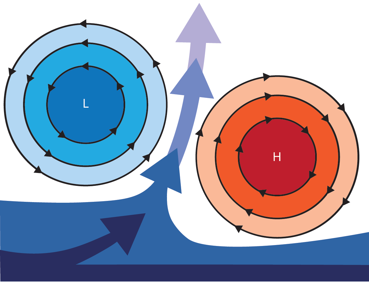
The life of an atmospheric river generally begins over the warm subtropical oceans. In the Northern and Southern Hemispheres, the process is the same, but the orientations are opposite; we’ll describe a Northern Hemisphere example (see figure 2). A developing low-pressure system creates a surface pressure gradient, which draws a tendril of warm, moist air northward toward the lower-pressure region. As air flows north, it is deflected to the east by the Coriolis force and begins to circulate counterclockwise around the low-pressure center to form an extratropical cyclone.
Figure 2.

Atmospheric rivers that form in the Northern Hemisphere occur between a low-pressure, counterclockwise-spinning cyclone and a high-pressure, clockwise-spinning anticyclone. Moist air drawn toward the low-pressure region (L) is deflected to the east by the Coriolis force. A paired anticyclone (H) constrains the flow to a narrow region, and the horizontal pressure gradient between the two systems leads to strong winds and moisture transport—the atmospheric river.

On the southeast side of the developing atmospheric river, a high-pressure center, known as an anticyclone, forms. Air flows clockwise around the anticyclone system, which increases the atmospheric river’s wind speed and constrains the flow of warm, humid air into a narrow region between the two systems. That narrow region is on the order of hundreds of kilometers across, whereas the cyclone and anticyclone can be thousands of kilometers across.
Those high- and low-pressure centers are not stationary: They are embedded within the larger-scale eastward flow of wind in the midlatitudes. As the systems travel both eastward and poleward, the filament of air is drawn along with them, carrying warm and moist air to higher latitudes as an atmospheric river. The pressure difference between the low- and high-pressure centers determines the strength of the winds. A steeper pressure gradient leads to faster winds because of geostrophic balance, an approximate balance between the pressure gradient and the Coriolis force.
Making landfall
As the warm, moist air propagates eastward, it may run into obstacles. Atmospheric rivers form over all midlatitude ocean basins, so they can eventually affect Africa, Australasia, East Asia, Europe, and both North and South America. Those that form over the North Pacific encounter the steep, mountainous terrain of the North American West Coast. The mountains force the moisture-rich air upward, which cools it and lowers the maximum amount of water vapor that can be in the air. That causes the water to rapidly condense from vapor, which leads to extreme rainfall events and flooding.
Many extreme rainfall events and major floods in California, Oregon, Washington, and western Canada are caused by atmospheric rivers. In 2025, prolonged rainfall from an atmospheric river led to a state of emergency in Washington and part of Canada and record-breaking water heights in several rivers. Extreme events can also lead to cascading hazards that include landslides and infrastructure failures, such as dam collapses. Yet atmospheric rivers can also be beneficial to those regions: The precipitation is a crucial component of local water resources and replenishes mountain snowpack across the western ranges. Similar processes occur in other mountainous midlatitude coastal regions, such as the Chilean Andes.
In contrast, when atmospheric rivers encounter smoother topography, such as that of the eastern US or eastern China, they tend to rain out more gently and steadily. But the storms still play an important role in determining those regions’ annual rainfall.
In addition to moving water vapor, atmospheric rivers carry heat from the lower latitudes. They are thus associated with warmer-than-average temperatures on the ground. In the summer, the combination of high temperatures and high water-vapor content in the atmosphere can lead to a transient enhanced greenhouse effect: Water vapor is a potent greenhouse gas that traps longwave radiation near the surface. The combination of high temperatures and humidity creates the conditions for high wet-bulb temperatures, which indicate low evaporative-cooling efficacy. Multiple days of high wet-bulb temperatures are called moist heat waves, and they are particularly dangerous for human health because they make it difficult for the body to cool via evaporation.
Changes under a warming climate
As temperatures increase, the amount of water vapor that can be in the air also increases. As determined by the Clausius–Clapeyron relation, the rate of that increase is 7% per kelvin of warming at the surface. In a warmer future, atmospheric rivers could therefore transport larger amounts of water vapor, which would lead to more extreme precipitation events and more dangerous moist heat wave conditions.
Though the relationship between change in climate and the amount of water vapor in the atmosphere is straightforward, the changes to winds and larger-scale weather systems are much less certain. The tracks that extratropical cyclones and anticyclones take in the midlatitudes are expected to shift toward the poles in a warmer climate. Atmospheric river activity could therefore expand into higher latitudes. The historical record suggests that there has already been an increase in the frequency of atmospheric river conditions across many regions of the middle and high latitudes, and that has led to increased rainfall and snowfall in many locations. How similar changes will manifest in the future and how atmospheric rivers will interact with other parts of the changing climate system are areas of active research.
Additional resources
► R. E. Newell et al., “Tropospheric rivers?—A pilot study ,” Geophys. Res. Lett. 19, 2401 (1992).
► H. F. Dacre et al., “How do atmospheric rivers form? ” Bull. Am. Meteorol. Soc. 96, 1243 (2015).
► M. D. Dettinger et al., in Atmospheric Rivers , F. M. Ralph et al., eds., Springer (2020), p. 141.
► S. R. Scholz, J. M. Lora, “Atmospheric rivers cause warm winters and extreme heat events ,” Nature 636, 640 (2024).
► A. E. Payne et al., “Responses and impacts of atmospheric rivers to climate change ,” Nat. Rev. Earth Environ. 1, 143 (2020).
More about the authors
Serena R. Scholz is a PhD candidate and Juan M. Lora is an associate professor in the earth and planetary sciences department at Yale University.