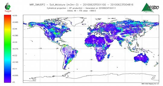
Discover
/
Article

Satellite maps global soil moisture

JUL 01, 2010
Physics Today
Nature : The European Space Agency’s Soil Moisture and Ocean Salinity ( SMOS) spacecraft has released its first map of Earth’s soil moisture. Launched in November 2009, SMOS derives soil moisture by measuring and analyzing the microwave spectrum emitted by the ground. In the map shown below, blue connotes dry soil; red connotes wet soil. The map was taken on 21 June, when the US midwest was unusually wet and the UK southeast was unusually dry.

15025/pt5024465_smos.jpg

Related content
/
Article
The finding that the Saturnian moon may host layers of icy slush instead of a global ocean could change how planetary scientists think about other icy moons as well.
/
Article
/
Article
After a foray into international health and social welfare, she returned to the physical sciences. She is currently at the Moore Foundation.
/
Article
Modeling the shapes of tree branches, neurons, and blood vessels is a thorny problem, but researchers have just discovered that much of the math has already been done.

Get PT in your inbox

pt_newsletter_card_blue.png
PT The Week in Physics

A collection of PT's content from the previous week delivered every Monday.

pt_newsletter_card_darkblue.png
PT New Issue Alert

Be notified about the new issue with links to highlights and the full TOC.

pt_newsletter_card_pink.png
PT Webinars & White Papers

The latest webinars, white papers and other informational resources.

By signing up you agree to allow AIP to send you email newsletters. You further agree to our privacy policy and terms of service.