Remotely Sensed Neutrons and Gamma Rays Reveal Ice beneath the Martian Surface
DOI: 10.1063/1.1510269
Modern Mars is cold, desolate, and dry. Its atmosphere contains a mere 0.03% of water vapor. Water can’t survive as a liquid. Only at the planet’s poles do the temperature and pressure let water exist, as ice, on the surface.
But Mars was once wetter. Giant canyons, networks of gullies, layers of sedimentary rocks, even features that resemble shore lines are visible on the surface. All these structures formed by the action of water. Carving all the water-worn features required a lot of water. According to Mike Carr of the US Geological Survey, the amount needed is equivalent to an ocean 500 meters deep covering the entire planet—far more than the atmosphere or ice caps currently store. Where the water went is one of the biggest Martian mysteries.
Now, a suite of nuclear physics instruments on board NASA’s Mars Odyssey spacecraft has identified what is almost certainly a new reservoir of water: ice frozen into subsurface soil. Three papers report the findings. 1 Their lead authors are William Boynton (University of Arizona), William Feldman (Los Alamos National Laboratory), and Igor Mitrofanov (Russia’s Space Research Institute).
Because the instruments probe just the top meter or so of the surface, it’s not clear yet whether the newly discovered ice deposits represent the tip of a vast mantle of ground ice or a thinnish layer. But whatever its true size, the ice is exactly—and gratifyingly—where theorists predicted it should be.
Kick out the neutrons
Odyssey has been orbiting the red planet since arriving there in October 2001. On board the spacecraft are three scientific experiments: a radiometer called MARIE, an infrared imaging spectrometer called THEMIS (see the
To spot chemical elements from its 400-kilometer-high orbital vantage, GRS relies on some energetic help. Cosmic rays, undeflected by the planet’s weak magnetic field and barely absorbed by its thin atmosphere, rain down on the Martian surface. A typical cosmic ray, a 1-GeV proton, penetrates tens to hundreds of centimeters into the surface before slamming into and dismembering whatever atomic nucleus lies in its way. Collision fragments, if charged, are soon absorbed, but neutrons travel farther.
Some back-scattered neutrons make their way into space, where GRS can detect them. Others beget gamma rays, either through collisionally exciting nuclei or through being captured by nuclei. The neutrons’ different fates make identifying the nuclear constituents of the surface possible.
Observers put the neutrons that emerge from the surface in three energy-based classes. Fast neutrons, the most energetic at 100 keV and up, flee without interacting. Thermal neutrons, the least energetic, collide so often that they acquire a Maxwell-Boltzmann distribution. Their median energy is typically a few tenths of an electron volt. Between the two extremes are epithermal neutrons. Because they suffer a modest number of collisions before escaping, these neutrons are more likely than their more interactive thermal kin to “remember” the few species they bumped into.
Gamma rays reveal nuclear identity because of their characteristic line energies: 2.2 MeV for hydrogen, 7.6 MeV for iron, and so on. Neutrons are coyer. When they bounce off nuclei, neutrons lose an amount of kinetic energy that depends on the mass of the nuclei. Hydrogen’s lone proton, weighing almost the same as a neutron, can slow a neutron with ease. Heavy nuclei are less effective moderators. So, a preponderance of significantly slowed neutrons means light nuclei are present. NASA’s Lunar Prospector exploited this phenomenon four years ago to infer the presence of ice at the bottom of craters on the moon.
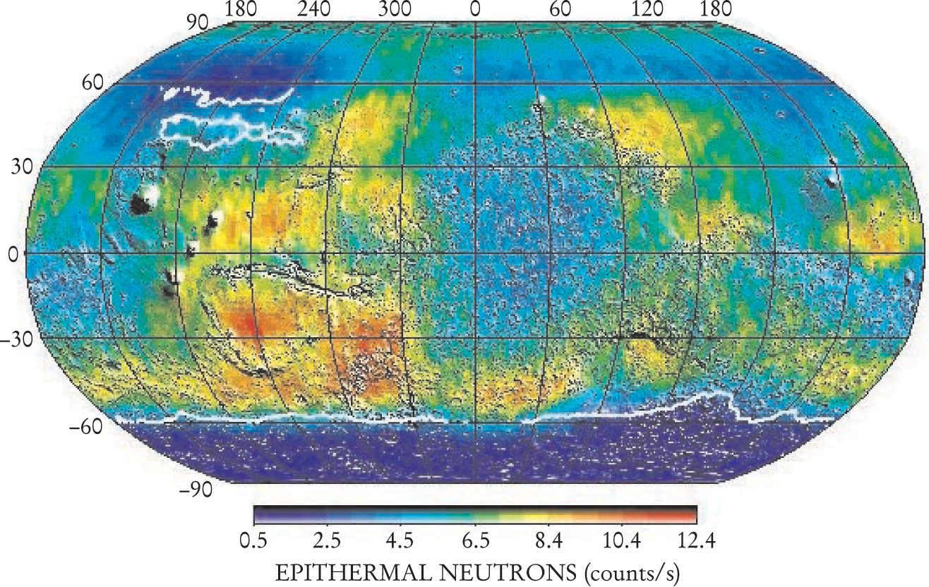
The adjacent figure shows that the epithermal neutron flux is noticeably deficient in a high-latitude belt around the south pole. In the same region, the 2.2 MeV hydrogen line is relatively stronger. A similar pattern could well exist in the north, but Odyssey couldn’t detect it because, at the time of the observations—northern winter—a seasonal blanket of carbon dioxide frost lay over the north pole, stifling the neutron and gamma-ray signals.
Quantifying the amount and distribution of water ice from gamma-ray and neutron emission is tricky. One needs to know what elements apart from hydrogen are in the soil and how they’re distributed. To derive results, the GRS researchers had to make several simplifying assumptions. Their models, which presume that hydrogen is present as water ice, incorporate the same mix of elements that NASA’s Mars Pathfinder discovered when it visited the Martian surface in 1997. The team also normalized the data by dividing the neutron and gamma-ray fluxes by the values found at the Viking 1 landing site.
For the ice’s depth distribution, the team considered two simple cases. In one, the ice-bearing soil extends right to the surface; in the other, a dry layer of variable thickness tops the ice-containing layer. Thermal and epithermal neutrons, thanks to their different behavior in the two cases, provide the discrimination.
Applying this approach, the GRS researchers found that the soil in high-latitude regions appears to harbor 35% (by weight) of water ice. That’s too much hydrogen to be in any kind of normal hydrogen-bearing mineral. Hydrides are also an unlikely chemical repository because the Martian atmosphere is so oxidizing. Moreover, GRS found water ice in the coldest regions. Hydrogen in other forms wouldn’t care much about the ambient temperature.
As for the vertical distribution of ice, the data favor a two-layer model, with the dry layer increasing in thickness toward the equator.
The red planet in infrared
Mars Odyssey’s thermal emission imaging system (THEMIS) took these infrared images of (roughly) the same patch of Martian surface earlier this year. Located 3° N of the Martian equator, the area is about the size of Dallas, Texas, and is close to one of the possible landing sites that NASA has picked for its 2005 Mars Exploration Rover project.
Despite spanning the same spectral range, the two images look quite different. That’s because the images were snapped at different times of the 24.6-hour Martian day: afternoon on the left; pre-dawn on the right. In the afternoon image, the brightest features are the ones that face the Sun, whereas the darkest are permanently shadowed. At night, sun-warmed surfaces cool at different rates depending on their physical properties. Dust-covered regions cool quickly. They show up as dark patches because small particles are efficient heat emitters. Bare rocky slabs, on the other hand, cool more slowly and appear brighter in the infrared.

How the surface responds thermally to solar radiation is important for predicting the diffusion of water vapor through porous soil. In their models, planetary scientists use a term called thermal inertia, defined as
The stark differences between the afternoon and predawn images reveal more than the thermal inertia of the Martian surface. Different geological structures, with different thermal properties and distributions, are deposited and eroded over time. But the changes aren’t steady. Dust doesn’t accumulate evenly over the surface, nor have rocks stopped forming and shifting. As seen with THEMIS, Mars is a dynamic place—both kinetically and thermally. (Images courtesy of Phil Christensen, Arizona State University.)
Remarkable agreement
The most remarkable aspect of the Odyssey GRS results is that the ice turns out to be exactly where modelers had predicted it should be. The white lines on the figure (see page 16) correspond to a theoretical prediction that the University of Colorado’s Mike Mellon and Bruce Jakosky made in 1993. 2 Their model accurately captures the distribution’s margin, as well as an island of ground ice in the northwest.
Mellon and Jakosky’s model, and those of their predecessors, builds on a pioneering 1966 paper by Caltech’s Robert Leighton and Bruce Murray. 3 The basic approach assumes an equilibrium between the diffusion of vapor into the soil and the vapor’s condensation into ice. Ingredients include the soil’s thermal inertia (see box), albedo, and microstructure.
The diffusion is exceedingly slow. One gram of vapor takes 1000 years to seep into and accumulate in the soil’s pores. Near the poles, where the surface temperature is much less than 200 K, the ice lies mere centimeters beneath the surface. Closer to the equator, the ice layer is deeper.
How deep the ice extends is an open question. In their model, Mellon and Jakosky include a term for geothermal energy that limits the vapor’s downward diffusion. The subsurface ice, they argue, occupies a thinnish layer. But the interior conditions of Mars are not well known, and that leaves open the possibility that GRS has found the long-sought repository of the water that created the canyons and other water-worn features. Only drilling in situ can settle the question definitively.
Finding a new reservoir of water on Mars—even if it’s frozen mud—inevitably raises the question of life. Intriguingly, the combination of a dry top layer and an ice-laden lower layer exists today in the Dry Valleys of Antarctica. There, despite the cold and dry conditions, lichen grows. Mars could turn out be the home of little green plants.

Cosmic rays bombard the Martian surface evenly from all directions, but the epithermal neutrons they kick out are depleted in a high-latitude band that skirts the south pole. The relative paucity of epithermal neutrons indicates the presence of light nuclei, presumably hydrogen in the form of water molecules.
(Adapted from ref. 1, Boynton et al.)
References
1. W. V. Boynton et al., Science 297, 81 (2002);https://doi.org/10.1126/science.1073722
W. C. Feldman et al., Science 297, 75 (2002);https://doi.org/10.1126/science.1073541
I. Mitrofanov et al. Science 297, 78 (2002).https://doi.org/10.1126/science.10736162. M. T. Mellon, B. M. Jakosky, J. Geophys. Res. 98, 3345 (1993).https://doi.org/10.1029/92JE02355
3. R. B. Leighton, B. C. Murray, Science 153, 136 (1966).https://doi.org/10.1126/science.153.3732.136


