Megaflashes: The world’s longest lightning discharges


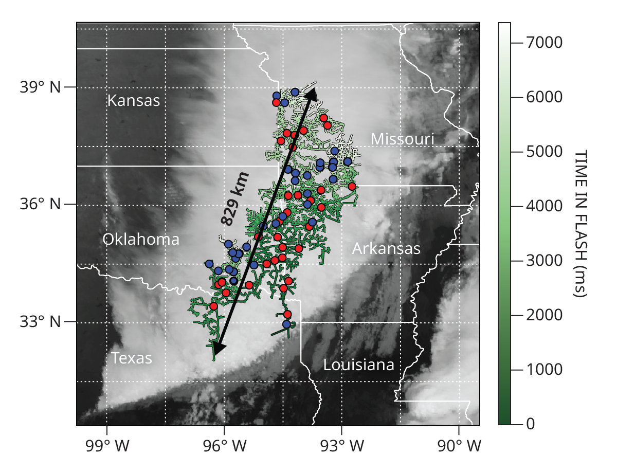
Given that lightning’s electric discharge moves at a significant fraction of the speed of light, how far can it travel during its lifetime? The length of lightning strikes, whether intracloud or cloud to ground, is typically less than 10 km. But in October 2017, one 7.4-second flash blazed an 829 km path from east Texas to near Kansas City, as shown in figure 1. Official US storm data show that the storm complex created significant hail, severe winds, and a few short-lived tornadoes over the central and southern Great Plains. Fortunately, no deaths resulting from the thunderstorm were reported.
Figure 1.

The world record for the largest megaflash lightning (green), certified by the World Meteorological Organization, struck the central US on 22 October 2017. The megaflash data shown here come from composite GOES-16 satellite imagery. Also shown are 116 associated cloud-to-ground discharges: 83 negative strokes (blue) and 33 positive strokes (red).
(Figure adapted from M. J. Peterson et al., “A new WMO-certified single megaflash lightning record distance: 829 km (515 mi) occurring on 22 October 2017 ,” Bull. Am. Meteorol. Soc. 106, 627, 2025.)
In 2025, after analyzing reprocessed satellite data, the United Nations World Meteorological Organization certified the 2017 flash as the new world record for the longest megaflash. In decades past, the idea that lightning could propagate more than 100 km horizontally was considered unlikely. Are megaflashes a different form of lightning? How are they monitored? And why do they matter?
The big spark
Most lightning flashes are born in the updrafts of convective cumulonimbus clouds. Within turbulent updrafts, which reach speeds of up to 50 m/s, conglomerates of soft hail called graupel collide with supercooled liquid water and ice particles; the ice particles transfer negative charge to the graupel. Given differences in terminal velocities, gravitational sorting typically redistributes lighter positively charged ice into the upper reaches of the updraft, and heavier negatively charged graupel descends. As the electric field strength increases, the air’s impedance is exceeded, and lightning occurs.
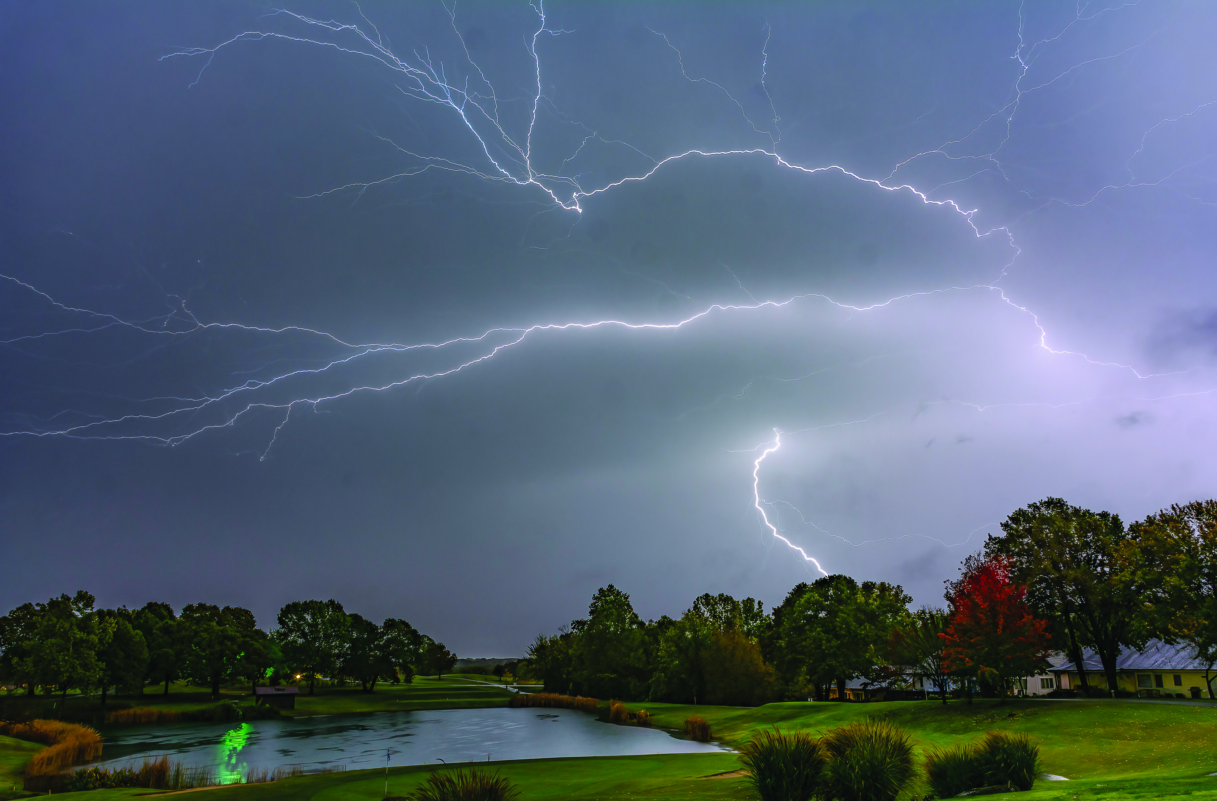
The hot, bright channels that you see during lightning strikes, such as the ones shown in figure 2, are called leaders. A spectacular cloud-to-ground stroke starts as a stepped leader discharge that descends incrementally to within tens of meters of the ground, where it connects with an upward leader that completes the circuit. The currents of the pencil-thin ionized plasma channel heat the air to 30 000 °C, causing a brilliant flash and the rumble of thunder. Cloud-to-ground strokes typically transport negative charge to Earth with peak currents in the 10–30 kA range, though about 10% are of positive polarity and can have peak currents up to an order of magnitude larger.
Intracloud discharges, which make up about 80% of all flashes, are bidirectional, quasi-horizontal leaders. Many flashes contain both intracloud and cloud-to-ground components. A megaflash is an intracloud flash with cloud-to-ground components—it’s just a much, much bigger spark than usual.
Figure 2.

Intracloud and cloud-to-ground components of an expansive lightning flash in Bella Vista, Arkansas, during the 22 October 2017 storm.
(Photo courtesy of Douglas Keck.)
The electrically charged regions in convective cumulonimbus clouds typically measure a few kilometers across, though some supercells span tens of kilometers. The advent of meteorological satellites revealed that thunderstorms can organize into much larger entities comprising multiple clusters arranged in a variety of recognizable configurations, collectively known as mesoscale convective systems (MCSs).
One type of MCS propagates as a long front of towering electrically active cores, known as a squall line, followed by extensive areas of shallower, layered clouds that produce gentle rain. During the warmer months, such systems traverse the central US, often persisting for more than 12 hours. Though far removed from active updrafts, those shallower clouds contain layers of weak electric charge.
Along with some locally generated charge, positively charged ice crystals lofted atop the distant convective towers recirculate rearward and downward into the shallow trailing clouds. Those pockets of slowly accumulating charge can become interconnected to form a cloudy capacitor large enough to cover a multistate area and provide an ideal environment for a megaflash.
Finding the megaflash
An early hint at the possibility of megaflashes came in the 1980s when videos taken from space shuttles documented unexpectedly large lightning flashes tens of kilometers long. In the mid 1990s, triangulated observations from ground cameras revealed eight red sprites—transient luminous phenomena that can occur during intense strikes—that appeared sequentially over a distance of 200 km above an MCS in Texas. The sprites emerged at intervals consistent with intracloud-leader propagation velocities, which signaled that they could possibly be connected by a single flash.
The ability to confirm a discharge more than 100 km long—the megaflash definition—was achieved in the late 1990s through the use of ground-based 3D lightning mapping arrays comprising radio receivers distributed around a city-sized region. One of about a dozen such research systems deployed worldwide is the North Georgia Lightning Mapping Array, which has eight receivers throughout the Atlanta metro area.
Like weather radar, such arrays are constrained by line-of-sight coverage, so it was fortuitous in 2007 when an array in Oklahoma captured a megaflash’s lightning channels traversing 321 km. That became the first record discharge length certified by the World Meteorological Organization.
Observing lightning from geostationary orbit solved the spatial coverage limitations. Launched in 2016, the first such detector was NOAA’s Geostationary Lightning Mapper on the Geostationary Operational Environmental Satellite GOES-16. High-speed optical detectors continuously report lightning flash rates and 2D lightning maps across the Americas and portions of the Atlantic and Pacific Oceans. The mapper domain covers two known hot spots for megaflashes: the Great Plains in North America and La Plata Basin in South America. More recently, EUMETSAT, the European Organisation for the Exploitation of Meteorological Satellites, launched its Meteosat Third Generation satellite system, with a lightning imager sensor that continuously monitors megaflash hot spots around the Mediterranean Sea and parts of Africa.
Because data-processing algorithms were not originally designed to recognize long-lasting, spatially extensive flashes, detailed postprocessing techniques were developed to identify megaflashes. Consequently, in 2025, the World Meteorological Organization was able to certify the 2017 megaflash as a world record. With ongoing global monitoring, that record may someday be surpassed, and our understanding of megaflashes’ parent convective systems will be enhanced.
Safety concerns
Studying the maximum extent of lightning also has important public safety implications. A single megaflash can unexpectedly produce a hundred or more cloud-to-ground discharges that strike tens to hundreds of kilometers away from active lightning centers. Megaflash cloud-to-ground strikes prompt concerns similar to “bolts from the blue”—rare cloud-to-ground strikes that escape their thunderclouds into the clear air for distances approaching roughly 15 km. Bolts from the blue can strike unexpectedly with deadly consequences. Megaflash cloud-to-ground strikes can, similarly, strike unexpectedly from cloudy skies (making them more like bolts from the gray) long after the apparent thunderstorm threat has ended. Moreover, some megaflash cloud-to-ground strikes pose additional hazards, such as exceptionally high peak electric currents and lengthy continuing currents, both of which can start fires and cause infrastructure damage.
Our growing understanding of megaflashes suggests that there are rare scenarios where existing lightning safety guidelines need finessing. The National Lightning Safety Council and NOAA advise “when thunder roars, go indoors” and wait there until 30 minutes after the final rumble of thunder before resuming outdoor activities. That guidance has been effective, and recent decades have seen historically low lightning fatalities in the US. The guidance, however, is based on the ordinary convective thunderstorms where most lightning occurs. The implications of megaflashes on the initiation of wildfires and the safety of activities that include large outdoor crowd control, the handling of explosive materials, space-vehicle launches, and wind-farm and utility grid operations will need to be increasingly scrutinized.
Additional resources
► R. Cerveny, Judging Extreme Weather: Climate Science in Action , Routledge (2024).
► W. A. Lyons et al., “Megaflashes: Just how long can a lightning discharge get? ” Bull. Am. Meteorol. Soc. 101, E73 (2020).
► M. Peterson, “A survey of thunderstorms that produce megaflashes across the Americas ,” Earth Space Sci. 10, e2023EA002920 (2023).
► M. J. Peterson et al., “A new WMO-certified single megaflash lightning record distance: 829 km (515 mi) occurring on 22 October 2017 ,” Bull. Am. Meteorol. Soc. 106, 627 (2025).
► World Meteorological Organization, World Weather and Climate Extremes Archive .
More about the authors
Randall S. Cerveny is a President’s Professor and directs the meteorology program at Arizona State University in Tempe. He is the World Meteorological Organization’s rapporteur of world records on weather and climate extremes.
Michael Peterson is the director of the Severe Storms Research Center at the Georgia Tech Research Institute in Atlanta.
Walter A. Lyons is a past president of the American Meteorological Society and spent his career as a lightning researcher.


