Move a plateau, change a climate
DOI: 10.1063/PT.3.3864
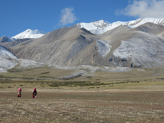
Spanning 2.5 million square kilometers between the Himalaya mountains and northwest China, the Tibetan Plateau towers 4.8 km above sea level and dominates the landscape of central and east Asia, as shown in figure
Figure 1.

Mount Kailash (left-most peak) and the western-most part of the Tibetan Plateau. Photo by David Zoeller.
Now researchers led by Ran Zhang (Climate Change Research Center; spokesperson for the group) and Zhongshi Zhang (China University of Geosciences) have shown that the evolution of Asia’s climate depended not only on changes to the plateau’s height but also on changes in its latitudinal position. 1 They used a series of climate simulations to estimate the difference in wind and precipitation patterns under two hypothetical scenarios: one in which a plateau formed in the tropics and one in which it formed in its modern-day position. The study helps to reconcile geological knowledge about the plateau’s ancient position with climate records, and it explains how monsoons may have evolved in response to changes in both latitude and elevation.
Tropical or subtropical?
By re-radiating solar radiation in the summer, the Tibetan Plateau heats the atmosphere more than occurs at the same altitude over the oceans, which have a greater heat capacity. With warming come strong vertical winds and an inflow of moist air from the Indian and Pacific Oceans, which result in the seasonal rain associated with the East Asian monsoons. The plateau’s position, which acts as a mechanical barrier to the subtropical jet stream, is critical in driving global circulation patterns.
Geologists hypothesize that in the early stages of the Indian and Eurasian continental plate collision between 40 million and 60 million years ago, the southern margin of a proto–Tibetan Plateau had begun to rise in the tropics, more than 1000 km south of its current position. 2 Due to plate tectonics, the land masses that made up the proto–Tibetan Plateau gradually shifted northward entirely into the subtropics.
But exactly how those proposed geological changes affected climate is uncertain. One way to resolve uncertainty is to look at climate proxies, such as fossils that indicate what vegetation grew, or at ancient sediments that offer clues about past seawater temperatures and oxygen content. Still, neither those proxies nor geological reconstructions alone provide a complete picture of Asia’s paleoclimate. Climate models offer a powerful means by which to test new theories derived from both.
Employing the widely used community atmosphere model 3 developed at the National Center for Atmospheric Research in Boulder, Colorado, Zhang’s team shows that if the plateau rose in the tropics, the Asian paleoclimate would have only been slightly drier in inland Asia and slightly wetter in east Asia compared with a plateau-free situation, and the paleoclimate would have lacked key seasonal features of a modern monsoon climate. 1 But if the Tibetan Plateau formed at its present location, the East Asian climate would have gradually developed modern monsoon characteristics alongside surface uplift.
By varying elevation and latitude, the researchers show that while a tropical plateau would not have led to a monsoon-like effect in Asia, even a plateau of modest elevation would have profoundly influenced when and where precipitation patterns developed. The work helps constrain the timing over which Asia’s monsoons may have originated.
Pinpointing position
In their study, Zhang and colleagues drew from a combination of geological sources to propose boundaries for an ancient Tibetan plateau. One widely accepted technique used to determine the ancient latitudinal position of a massif is to observe how magnetic minerals are aligned within rock layers. The minerals record the local orientation of Earth’s magnetic field at the time the rock formed. Using that technique, Yabo Tong and colleagues
4
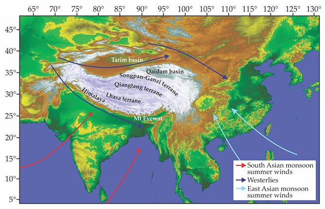
found that 60 million years ago, a part of the southern Tibetan uplands now known as the Lhasa terrane (see figure
Figure 2.

Map of southern Asia showing major tectonic terranes and the major wind patterns associated with the South Asian Monsoon and East Asian Monsoon in summer. Fossil and paleomagnetic evidence have led geologists to believe that those terranes uplifted separately. (Adapted from ref.
Oxygen isotopes in the local sediments can also be used to estimate elevations in the past. The heavier version, 18O, preferentially falls out in rain or snow as air is lifted when it encounters a mountain, so rising air is progressively enriched with the lighter version, 16O, relative to its counterpart. Abundant 16O in the Tibetan Plateau sediments suggests that by 53 million years ago, the Lhasa terrane and its northerly neighbor, the Qiangtang terrane, had reached nearly their present-day elevation of 4.5 km and were separated by a system of deep valleys trending east–west. 5
Greater uncertainty surrounds estimates of the elevation history of the plateau’s northernmost Songpan-Ganzi terrane. Water quickly evaporates off the leeward side of the mountains, so isotopic evidence is unreliable. Yet another complication comes from the Himalaya mountains themselves, which today create a significant barrier to airflow. They began to form during the India–Asia collision but only reached their present 8 km elevation much later, some 15 million years ago.
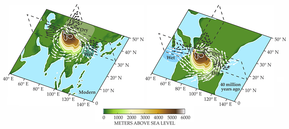
Robert Spicer (the Open University in Milton Keynes, UK) agrees that the effect of the paleo–Tibetan Plateau’s latitude has been “largely overlooked,” and climate models are “useful for raising the issue.” Still, as with any model, specific outcomes “should not be thought of as representing precise past conditions.” Zhang and company focused on the distinction between a plateau situated in the tropics and one in the subtropics, as shown in figure
Figure 3.

Effect of the modern and the ancient Tibetan Plateau on Asia’s climate. Dark blue coloring indicates increased precipitation; light green indicates decreased precipitation. White arrows indicate water vapor transport; black arrows are air circulation. (Adapted from ref.
Clarifying climate
The timing of the onset of the East Asian monsoon is controversial. Although analysis of windblown sediments led scientists including Zhang’s colleague Zhengtang Guo to assume that Asia’s present-day monsoons originated between 22 million and 25 million years ago, fossil evidence of ancient vegetation has led climatologists to propose that monsoon rains began to develop around 40 million years ago during the India–Asia collision.
A 2003 paper by Akio Kitoh (Meteorological Research Institute, Japan Meteorological Agency) and colleagues highlights the crucial impact of the elevation and extent of the Tibetan Plateau on climate. 6 The researchers’ global circulation models included stepwise changes in worldwide topography, from 0 to 100% of current values, and showed that the Asian monsoon patterns intensify with higher terrain but that trends vary regionally. Zhang and his colleagues used a higher-resolution model and considered asynchronous uplift across different parts of the Tibetan Plateau.
In the new study, the researchers attempted to separate the impact of the plateau’s latitude on ancient climate from a myriad of other signals. 1 “Zhang’s work is a systematic sensitivity experiment on latitudinal position and elevation of the Tibetan Plateau, [but it does not describe] paleoclimate change precisely and fully,” says Kitoh.
Paleoclimate modelers can simulate different latitudinal extents to constrain the proxy-based northern and southern reconstructed margins of the Tibetan Plateau. Zhang and company simulated plateau locations ranging from the modern position (26–40° N) to a tropical extreme (11–25° N). They considered different latitudinal extents and both high and modest elevations.
The simulations show that even a broad, moderate elevation plateau—at the extreme case, extending from 11° N to 40° N with an elevation of 2.5 km—intensifies the dry inland climate and enhances East Asian precipitation with respect to the plateau-free scenario. Simulations of narrower plateaus at different latitudes show that those trends persist and are more pronounced when the plateau’s northern margin extends further into the subtropics. “Our sensitivity experiments indicate that the northern margin exerts a particularly strong influence on climate and atmospheric patterns,” says Zhang.
Missing pieces
The models’ adjustable parameters—including global land–sea distribution, topography, sea-surface temperatures, and atmospheric carbon dioxide concentrations—embody uncertainties regarding ancient climate, as do vegetation and ice-sheet ground cover. Zhang and colleagues selected vegetation and land–sea distribution from the literature and simulated oceanic and atmospheric properties. “More experiments are needed to further investigate the climate effects of these different parameters,” says Zhang.
Today the East Asian summer is warm and wet and the winter is cold with strong northeasterly winds. But that seasonal distinction does not emerge under any of Zhang’s ancient conditions. For example, although summer East Asian wind patterns with a Tibetan Plateau in the tropics may have been similar to conditions today, low-level southeasterly winds would have dominated in the ancient winter, indicating almost no seasonal reversal.
To comprehensively describe the evolution of East Asia’s climate, models need to account for global factors. For instance, the ancient Paratethys Sea once covered much of what is now central Europe and western Asia. The marine environment would have driven the type of land–sea thermal contrast that contributes to today’s monsoon climates. As the sea retreated, its influence changed. In another example, the northward movement of Australia led to the formation of an anomalously warm region in the Pacific Ocean, known as the West Pacific Warm Pool, which is thought to have had a major influence on global climate.
Alexander Farnsworth (University of Bristol) points out that attempting to evaluate model results and disentangle the effects of other global forcings becomes difficult because “you cannot be sure that a different structure of the plateau might also have the same impact on the hydrological cycle that is shown in the proxy-based records for the East Asian monsoon.”
Still, examining the relationship among the Tibetan Plateau, its latitude and elevation, and the climate of the surrounding area provides an important step toward reconstructing Asia’s climate history. The approach offers a new constraint for testing theories about how other factors, such as global temperature changes and vegetation, affected ancient conditions.
References
1. R. Zhang et al., Earth Planet. Sci. Lett. 484, 295 (2018). https://doi.org/10.1016/j.epsl.2017.12.034
2. W. Huang et al., Tectonics 34, 594 (2015). https://doi.org/10.1002/2014TC003787
3. R. Neale et al., J. Clim. 26, 5150 (2013). https://doi.org/10.1175/JCLI-D-12-00236.1
4. Y. Tong et al., Earth Planet. Sci. Lett. 475, 1 (2017). https://doi.org/10.1016/j.epsl.2017.07.026
5. R. Spicer, Plant Divers. 39, 233 (2017). https://doi.org/10.1016/j.pld.2017.09.001
6. M. Abe, A. Kitoh, Y. Yasunari, J. Meteorol. Soc. Jpn. 81, 909 (2003). https://doi.org/10.2151/jmsj.81.909


