Martian icecap hosts a massive CO2 deposit
DOI: 10.1063/1.3603907
Earth’s obliquity, the angle between its spin and orbital axes, is responsible for the seasonal variations in our weather. In the summer, we get longer hours of daylight, more direct solar heating, and, as a result, warmer temperatures. Thanks to the stabilizing influence of the Moon, the angle, currently 23°, doesn’t change much.
Mars’s current obliquity, 25°, is similar to Earth’s. But because Mars doesn’t have a large moon, its obliquity wobbles by up to tens of degrees on time scales of hundreds of thousands of years. The Martian climate experiences both annual and obliquity-driven cycles; the latter have a profound effect on the planet’s polar icecaps. Substantial amounts of material sublimate and are redeposited, creating a complex structure of overlapping layered deposits.
Most of those deposits are primarily water ice. Although the Martian poles are cold enough to freeze carbon dioxide, CO2 ice has so far been found only in seasonal frosts and a small perennial deposit a few meters thick. But now, data from the Mars Reconnaissance Orbiter reveal at least one large deposit of CO2 ice. 1 If that CO2 were vaporized, as it certainly was at some point in the past and will be again in the future, it could nearly double the average pressure of Mars’s thin, CO2-based atmosphere. Such an increase would have important consequences for the frequency and intensity of dust storms and the stability of liquid water on the Martian surface.
CO2 or H2O
The data came from an instrument called SHARAD, for “Shallow Radar”—so named to distinguish it from a second, lower-frequency sounding radar in orbit around Mars. In operation since 2006, SHARAD has been probing the first kilometer beneath the Martian surface with a vertical resolution of about 10 m. In 2008, Roger Phillips (Southwest Research Institute, Boulder, Colorado) became interested in using SHARAD data to study the geological history of Mars’s southern icecap.
One radar slice through the icecap is shown in figure 1a. Discrete layering is easily visible in some parts but much messier in others. In the figure’s upper right, bounded by the blue and red lines and interrupted by the layer marked in purple, is a reflection-free zone (RFZ), from which there is almost no radar signal. Phillips and colleagues were drawn to the RFZs, of which they found four, because of the ease of identifying and mapping them from the radar data. Because the RFZ shown in figure 1 features a rugged, craggy lower boundary, the researchers were able to determine its composition using a clever technique.

Figure 1. (a) A slice through Mars’s southern polar icecap, as seen by the Shallow Radar instrument on the Mars Reconnaissance Orbiter. The ice surface is shown in blue; some of the subsurface reflectors are highlighted in purple, red, and green. (b) Part of the same radar track converted into an elevation profile, based on the determination that the reflection-free zone, between the blue and red lines, is CO2 ice. (Adapted from ref.
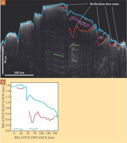
To convert a radargram into an elevation map, one multiplies the radar’s transit time by the speed of light through the material, which depends on the material’s permittivity at radio frequencies. Water ice has a permittivity of 3.15; CO2 ice, 2.12.
Because of the rugged lower boundary, using the wrong permittivity for the RFZ yields unrealistic distortions in the underlying topography. A peak in the RFZ’s lower boundary, for example, would show up as a peak or depression in all the reflecting interfaces under it. But because those interfaces formed millions of years apart by unrelated processes, their topographies should be entirely uncorrelated. Furthermore, the deeper interfaces, such as the one shown in green in figure 1, should be very smooth. Using those two criteria, the researchers found that the RFZ’s most realistic permittivity was 2.0–2.2, an excellent match to that of CO2 ice. One of the resulting elevation profiles is shown in figure 1b.
Extrapolating south
Because the Mars Reconnaissance Orbiter never reaches latitudes south of 87° S, the SHARAD data cover only part of the RFZ, as shown in figure 2a. To determine the RFZ’s full size, the researchers compared their data with a map of the geologically distinct layers visible on the surface. They found that the RFZ coincides with a layer called AA3—the two As refer to the layer’s age (Amazonian) and location (Planum Australe).

Figure 2. (a) Radar data of the reflection-free zone (RFZ) near Mars’s South Pole are overlaid on a map of geologic units visible on the icecap surface. The radar tracks’ colors indicate the RFZ’s thickness. (b) In this map of the same region, the thickness data are extrapolated over the area of geologic unit AA3. (Adapted from ref.
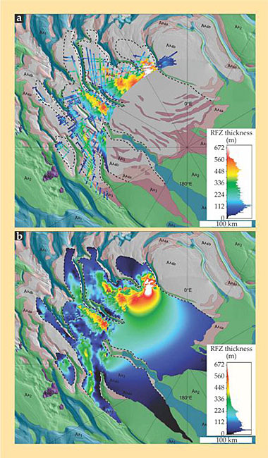
The areal extent of AA3 is known, but not its thickness; to estimate that, the researchers extrapolated from their data using a minimum-curvature method. Figure 2b shows the result, which gives an RFZ volume of 10 000–12 000 km3. That’s about the size of Lake Superior, and it’s 30 times the volume of the only previously known perennial CO2 deposit.
A wet and stormy Mars?
Six hundred thousand years ago, when Mars’s obliquity was 35° (the maximum for the past million years), it’s plausible that much of the RFZ material was in the atmosphere, which would raise the mean atmospheric pressure from 6 mbar to 10.5 mbar. Greater atmospheric pressure, though still just 1% of Earth’s, means greater potential for windblown dust to alter the Martian landscape. The increase is especially significant because water’s triple-point pressure—the lowest pressure at which liquid water can exist without boiling—is just above 6 mbar. Most of Mars would still be far too cold to host long-lasting liquid water (greenhouse warming from the additional atmosphere would be modest and may be entirely negated by more severe seasonal CO2 frosts), and in those parts that aren’t so cold, the atmosphere would be so dry that any water would evaporate. But just like on Earth, water under a dry atmosphere is much more stable than water at its boiling point.
The possibility of stable liquid water over large parts of the Martian surface may help to explain certain features—gullies and rocky outcrops—that show signs of having been formed from sedimentation or erosion by water. 2 (See the article by Bruce Jakosky and Michael Mellon in PHYSICS TODAY, April 2004, page 71 .) Some gullies seem to have formed in the past few million years. Says Phillips, “This certainly changes the way we interpret observations of Mars’s current climate and possibly current water-driven surface processes.”
References
1. R. J. Phillips et al., Science, *NM2*1. [[RR. J. PhillipsR]][[Ret al.R]], [[IScienceI]] (in press), doi:10.1126/science.1203091.
2. M. C. Malin and K. S. Edgett, Science 288(5475), 2330 (2000).https://doi.org/10.1126/science.288.5475.2330
More about the authors
Johanna L. Miller, jmiller@aip.org


