Climate change in the Arctic accelerates
DOI: 10.1063/PT.3.3688
As Arctic sea ice retreats as a result of rising regional air and sea temperatures, scientists are scrambling to understand the effects on Earth’s climate and weather at lower latitudes. An increasingly ice-free Arctic Ocean in summertime has profound implications—some good, some bad—for naval operations, fisheries, commercial navigation, and natural resources development.
Air temperatures above the Arctic Circle are warming at twice the global average. But the warming that occurred there in 2016 is unprecedented: Last year the average air temperature in some parts reached 6 °C above the 100-year average, said Jeremy Mathis, of NOAA’s Arctic Research Office. Sea-surface temperature in August 2016 was 5 °C above the 1982–2010 average in the Barents and Chukchi Seas and off the east and west coasts of Greenland. And where Arctic warming excursions had once been confined to the summer months, temperature anomalies have now propagated to the cold months: Average monthly temperature records in 2016 were observed in January, February, October, November, and December.
Polar warming is affecting weather patterns at lower latitudes too, as the jet stream, which is created by the gradient between polar and temperate air masses, meanders and brings warmer conditions to the western US and colder winters to the Eastern Seaboard. (See the article by James Overland, Physics Today, March 2016, page 38 .) “What happens in the Arctic no longer stays in the Arctic,” said Craig McLean, NOAA’s acting chief scientist. McLean and Mathis were among the speakers at a July biennial conference in Washington, DC, on the effects of the Arctic’s diminishing ice.
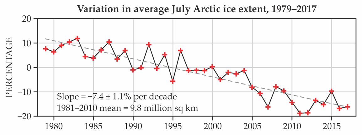
Last year’s Arctic Ocean sea-ice minimum, 4.1 × 10⁶ km2, tied with 2007 for the second lowest since satellite observations began in 1979, and this year’s annual ice retreat is on course to approach the record low coverage of 3.4 × 10⁶ km2 set in September 2012. The 10 lowest observed September ice minimums have occurred since 2007, according to National Snow and Ice Data Center (NSIDC) statistics.
Climate models generally predict the Arctic Ocean will become ice-free for parts of the summer between 2040 and 2070. But Mark Serreze, director of the University of Colorado–based NSIDC, foresees an essentially ice-free Arctic—generally defined by scientists as less than 1 × 10⁶ km2—as early as 2030.
The winter sea-ice maximum in March of this year was the lowest in the satellite record. This past winter was “absurdly warm,” Serreze says, but more typical spring temperatures have slowed the seasonal melt somewhat.
Rapid change is also occurring in Greenland, where the onset of ice-sheet melting in 2016 was the second earliest on record. But despite moderately higher temperatures and high air pressure, which brings warm southwesterly winds over the western part of the subcontinent, less than 20% of the ice-sheet area was melting through 30 June. That was the lowest since 2009, according to the NSIDC.
Even if the global temperature increase from its preindustrial level could be held to 2 °C—the target agreed to under the United Nations Framework Convention on Climate Change—warming will be amplified to around 5 °C in the Arctic, with a winter temperature increase of up to 7 °C, said Mathis. “Regardless of any mitigating efforts we put in place now, the Arctic will be a fundamentally different environment over the next few decades than it has been. So we have to begin preparing for that.”
In an interview, Mathis acknowledges some benefits to Arctic warming, including access to natural resources and the resulting increase to the tax base that could provide for native communities. And he says a growing tourism trade in the region will increase public awareness of the rapidity with which the changes are occurring. But he adds, “I would never spin those changes as a net positive.”
Traffic grows, slowly
Retreating sea ice brings more traffic to the Arctic and actually increases the need for icebreaking and coast guard patrols. Brenda Ekwurzel, director of the climate science program at the Union of Concerned Scientists, says sea ice behaves more unpredictably as it thins and breaks up: “When I was a researcher in the Arctic years ago, we could depend on the ice behaving in a certain way. With more ice in open water, the wind can blow ice floes into each other, creating ridges that can pile up tens of feet high, compared to the 2-meter average thickness of two-year ice.”

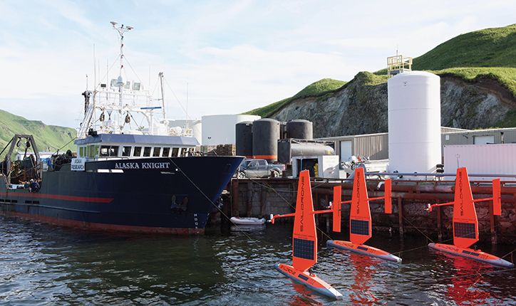
Sail drones were deployed for the first time in Arctic waters in July. The wind-powered autonomous craft gather information on physical, biological, and chemical characteristics of the seas.
SAILDRONE INC
Growing commercial shipping, including cruise ships, raises the likelihood of a maritime accident. Days may be required to respond to a request for assistance from a cruise ship in the high latitudes. Last year the Crystal Serenity, carrying 1700 passengers and crew, became the first cruise ship to transit Canada’s Northwest Passage. It’s due to sail again this year, and European cruise ships are plying the waters off Norway and eastern Greenland.
Summertime transits through the Canadian route increased from 5 in 2011 to 16 last year, according to the National Ocean Economics Program at the Middlebury Institute of International Studies at Monterey in California. Most trips were by private yachts. Transits of the Northern Sea Route off the Siberian coast peaked at more than 70 in 2013. The number fell to 19 last year, likely due to low oil prices reducing the cost of the far longer route through the Suez Canal.
Still, experts don’t expect a major increase in shipping traffic through the Arctic anytime soon. “The Northwest Passage will never become a shipping lane,” said conference presenter David Jackson, special projects adviser with the Canadian Ice Services. “Nobody would commit their ships there, because there is no infrastructure. And you have constrained maneuvering room if you encounter some ice there. It’s too unpredictable.”
Lawson Brigham, a geography professor at the University of Alaska Fairbanks and a former icebreaker captain, agreed. “You can technically get through. The question is can you make a euro or a dollar. Most say you can’t,” he said.
But bulk carrier and tanker traffic will increase, particularly in Russia, as the nation increasingly exploits its Siberian natural resources. The Russian coastline usually opens up for longer than the opposite side of the pole in the summertime as the Beaufort Gyre and Transpolar Drift draw ice floes away from Siberia toward Greenland and the Canadian archipelago.
Russia just completed construction of a year-round liquefied natural gas (LNG) terminal at Sabetta, on the Yamal Peninsula, said Natalia Kutaeva of Russia’s Marine Rescue Service. Fifteen tankers reportedly are being built to carry the LNG: west to Europe during the winter months and east to Asia during the warm part of the year. The first ship tied up in Sabetta in March on a dry run.
Alexey Knizhnikov, head of the oil and gas program at the World Wildlife Fund Russia, estimated during the conference that an LNG tanker will pass through the Bering Strait every 45 hours during the summer. He said shipping in the Arctic Ocean will increase further as Russia follows through on plans to mine metal ores and coal deposits in northern Siberia.
Royal Dutch Shell abandoned its offshore Arctic oil exploration operations in 2015, and Canada, Russia, and the US all imposed moratoriums on offshore leasing last year. But drilling is occurring in the Barents Sea, where the Norwegian government in June offered additional areas for leasing, and in the Pechora Sea south of Novaya Zemlya, Russia. Senator Lisa Murkowski (R-AK), another conference participant, said the North Slope’s estimated 30 billion barrels of oil and 231 trillion cubic feet of natural gas will lure the industry back, assuming President Trump’s executive order reopening offshore leasing there withstands legal challenges.

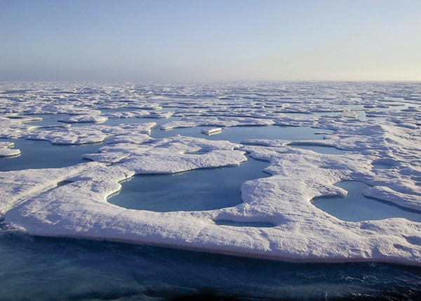
Melt ponds like these that have formed on Arctic Ocean sea ice off Barrow, Alaska, accelerate ice melting as the dark blue meltwater absorbs sunlight better than the surrounding ice.
JEREMY MATHIS/NOAA
Although the eight member nations of the Arctic Council are committed under a 2013 agreement to cooperate on oil spills, they aren’t prepared for an oil spill in the Arctic Ocean itself, said Paul Zukunft, commandant of the US Coast Guard, during his conference presentation. Some cleanup equipment has been prestaged and contingency plans developed for Alaskan waters, but the 2010 Deepwater Horizon disaster in the Gulf of Mexico showed how difficult cleanup can be even where waves are just 1.2 meters (four feet) high. “Four-foot seas in the Arctic would be a pretty good day,” he said.
A relatively small oil spill of 400 tons in 2015 off Sakhalin Island, well below the Arctic Circle off Russia’s east coast, showed gaps in Russia’s cleanup technology and governance, said Knizhnikov.
Icebreakers would be essential to any oil spill cleanup effort. Russia has 41, including 4 nuclear-powered ships, homeported along its 7000 km Arctic Ocean coastline. One of the nuclear vessels, the Fifty Years of Victory, cut a path to a research ship that had been stuck in ice for six days last October. Scientists had been searching with sonar for the wreckage of the USS Jeannette, which was crushed by ice in 1881 on a polar expedition north of Siberia. Kathy Crane, a visiting professor at the University of Hawaii at Manoa who was one of two Americans aboard the rescued vessel, said the rescue would have been more complicated in US waters.
The US has two operational polar icebreakers, but only the Polar Star has year-round capability. The ship is 40 years old and is due to be retired in 2020. The Healy, a light icebreaker commissioned in 2000, can cut through newer, thinner ice. Two NSF-owned research ships, the Nathaniel B. Palmer, operated by Edison Chouest Offshore, and Sikuliaq, operated by the University of Alaska Fairbanks, have limited icebreaking capability. The Palmer generally operates in the Antarctic; Sikuliaq operates in the Arctic. Each vessel can accommodate a scientific staff of around 30.

Percentage change in ice extent relative to the average July coverage, 1981–2010.
NATIONAL SNOW AND ICE DATA CENTER, UNIVERSITY OF COLORADO BOULDER
The US Coast Guard is in the early stages of procuring three heavy icebreakers, the first of which is expected to be delivered in 2023. Each will have dedicated research space. The initial vessel is estimated to cost $900 million, and the follow-ons will be somewhat cheaper.
Canada has six icebreakers, two of which are heavy-duty.
The lack of ice-capable ships in the region means the coast guard would be unable to enforce regulations should fisheries migrate into the high latitudes along with warmer waters, said Zukunft. Although an international moratorium is in place on commercial fishing in the Arctic, there are ice-free “doughnut holes” in the central Arctic Ocean where any nation now plying the North Pacific could enter and fish, says Mathis.
Mapping and modeling
Less than 5% of the US Arctic Ocean is mapped to modern survey standards, Murkowski said. Some charts of the waters off the North Slope include soundings that were taken with lead lines during James Cook’s third voyage in 1778, she noted. At its current pace, completing the surveys will take 100 years.
Today’s autonomous technologies for undersea mapping require vessels that can cost up to $60 000 per day to operate and a capital investment of up to $1 million, according to the Shell Ocean Discovery XPrize, which is offering $7 million for more affordable technologies. Some companies, notably those laying undersea cables, pay for their mapping, but they often consider the data proprietary, said conference presenter David Millar, vice president of Fugro (USA), which provides hydrographic surveying services.

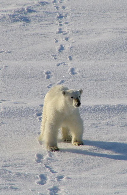
As Arctic sea ice retreats, polar bears are spending more time on land. Those that remain on the ice are swimming longer distances.
JEREMY MATHIS/NOAA
Although submarines have operated in the Arctic for decades, the US Navy wants to increase its surface presence there for defense and to uphold sovereignty in US waters. “How the ice is melting, refreezing, and moving across time is important to us to operate,” said conference participant David Hahn, chief of naval research. The navy also wants to know the effects that Arctic weather and other environmental factors have on acoustic propagation. “My weapon doesn’t operate predictably unless I’ve tuned it to the environment,” he said. “If we don’t have the right model, we’re just wasting bullets.”
Better observations needed for navigation and for modeling are being supplied by new autonomous drifting sensors and sea gliders deployed by NOAA. Already in place is a fleet of 105 buoys, maintained by the International Arctic Buoy Program, that provide real-time data on air pressure, sea and air temperatures, and ice movement. Mostly deployed on ice, they have an average life span of 18 months.
To measure ice thickness, NOAA has buoys designed to drift and become locked into the ice pack. In July the agency launched three wind-powered sail drones from the Alaska Peninsula. They are equipped to measure physical, biological, and chemical parameters, including acidification, in the ocean and atmosphere.
The Soviet Union began deploying manned ice-drifting stations in the Arctic in 1937, and the program has been continued by Russia. Researchers live on the ice floes for months, taking measurements of sea chemistry, weather, marine biology, and other conditions and mapping how the ice drifts.
More meteorological observing stations in the region would help improve the performance of the National Weather Service’s Arctic weather model, said conference speaker Carven Scott, director of the NWS Alaska Region. The same is true for sea-ice models, says Mitchell Bushuk, a climate modeler at NOAA’s Geophysical Fluid Dynamics Laboratory in Princeton, New Jersey. The lab’s model currently is fairly good at predicting sea-ice extent up to three months ahead, based on satellite sea-surface temperature data and on the subsurface ocean temperature, atmospheric temperature, and salinity data acquired from autonomous floats, moored buoys, and ships. But Bushuk thinks improvements could lengthen the prediction window to 24 months, since ocean temperatures, the primary influence on sea ice, evolve far more slowly than weather—anomalies persist for months or years.
Greater spatial coverage of sea-ice thickness would improve model performance, Bushuk says, and his lab is working toward assimilating thickness data from satellites into the model. Those observations, obtained using synthetic aperture radar, are accurate only during winter months, Bushuk explains, because melt ponds that form on sea ice during the warm months confound satellite algorithms that distinguish ice from water.
More about the authors
David Kramer, dkramer@aip.org


