Calving icebergs may cause glacial earthquakes in Greenland
DOI: 10.1063/1.2982109
Most earthquakes follow a simple scaling law: The duration in seconds of slip on the fault is proportional to 10 M/2, where M is the earthquake’s moment magnitude, a dimensionless number logarithmically related to the energy release. A typical M = 5 earthquake lasts 2 seconds; an M = 7 one, 20 seconds. The short duration gives rise to the efficiently radiated high-frequency seismic waves most often used to detect and locate earthquakes around the world.
But earthquakes exist with durations—from tens to thousands of seconds, say—much longer than the scaling law would suggest. And because they radiate more of their energy as long-period waves, the events often go undetected. In 2003 Göran Ekström, a seismologist at Columbia University, was looking for such oddballs. He systematically mined three years of archival data from the global seismographic network, which monitors about 200 seismometers distributed worldwide. His algorithm filtered the data in the long-period band between 35 and 150 seconds and checked whether a coherent-energy signal could be traced to any of some 5000 different locations on Earth.
Surprisingly, the grid search uncovered hundreds of never-before-cataloged earthquakes. And dozens, whose magnitudes ranged between 4.6 and 5.1, came from glaciated regions, primarily Greenland, where they clustered along coastal ice streams and outlet glaciers (see figure 1). The discovery prompted Ekström, with his then graduate student Meredith Nettles and Boston University geophysicist Geoffrey Abers, to propose a bold hypothesis: Huge 1014-kilogram chunks of glacial ice a kilometer thick and the size of Manhattan may sometimes lurch forward a few meters along their beds within time spans as short as a minute. 1

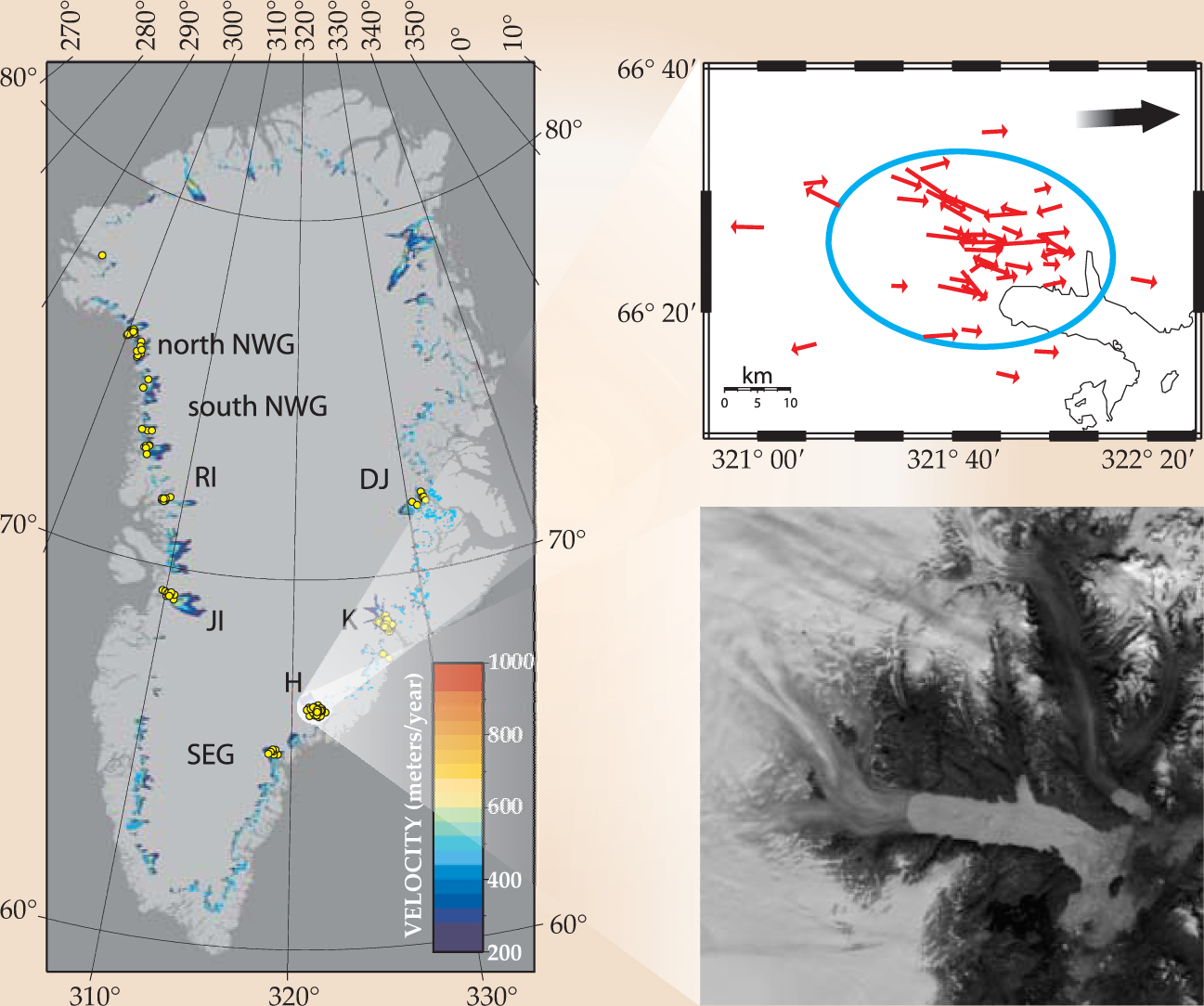
Figure 1. 184 glacial earthquakes are plotted as circles on this map of Greenland. All originated from fast-moving glaciers. The three largest—Kangerdlugssuaq (K), Jakobshavn Isbrae (JI), and Helheim (H)—account for about 72% of the seismic events. The right-hand panels are expanded views of the Helheim glacier. The location and force of each earthquake are indicated by the red vectors at top and its topographic details are pictured at bottom. All the forces lined up nearly parallel to the glacier’s flow direction given by the black arrow; vectors pointing in the reverse direction are artifacts of the seismic model. Other glacier names are Daugaard Jensen (DJ), southeast Greenland (SEG), Rinks Isbrae (RI), and northwest Greenland (NWG).
(Adapted from refs. 3 and 4.)
Inland, Greenland’s ice streams are pretty much frozen to bedrock, viscously creeping to the sea. Closer to the coastline, those streams can surge intermittently when meltwater makes its way to the bed and lubricates the flow. But those surges were thought to last from a few days or weeks to a few years, not minutes. Moreover, all prior seismic measurements of glacial regions described events known as icequakes—the fracturing of ice required to generate cracks and crevasses and break off small icebergs. Those processes tend to cause tremors with magnitudes around M = 1 or 2, some 10 000 times weaker than the new class of seismic events. The difference inspired Ekström to coin the term “glacial earthquakes.”
Like icequakes, glacial earthquakes are associated not with tectonic faults in bedrock but with events borne out of ice–rock dynamics. Indeed, Ekström’s team found the seismic-wave signals best fit a landslide model, in which the waves are generated by an accelerating and decelerating ice mass. And in 2006 his broader survey of the global seismic network conducted with Nettles and Harvard University’s Victor Tsai revealed a strong seasonal dependence in the frequency of Greenland’s glacial earthquakes. Between 1993 and 2005, they were nearly five times more prevalent during summer than winter, an effect the team tied to the presence of the friction-reducing meltwater. What is perhaps more significant, the last three of those years saw a pronounced increase in seismicity, an indication of how sensitive the phenomenon may be to temperature changes in the climate. 2,3
If glacial earthquakes are landslides, what part of the glacier is actually sliding, and how? Seismic signals alone—especially ones so depleted of high frequencies—cannot pin that down; the location of each earthquake is uncertain by several kilometers. The question is important because it may offer insight into another of planetary importance—what controls how fast a glacier drains its ice into the sea? During the period of increased seismicity, many of Greenland’s outlet glaciers, including its three largest, accelerated by more than 50%. If all of Greenland’s ice sheet were to melt, sea level would rise by 7 m. (See the article by Josefino Comiso and Claire Parkinson in Physics Today, August 2004, page 38. )
A model fit
Recent measurements are now calling Ekström’s bold hypothesis into question. Earlier this year 4 the University of Washington’s Ian Joughin and colleagues analyzed satellite images of the Helheim and Kangerdlugssuaq glaciers taken between 2001 and 2006. They found that glacial earthquakes had occurred during episodes when icebergs calved into the sea and the glaciers retreated. And for the past two summers, Nettles (now on faculty at Columbia) and colleagues have installed and monitored a network of global positioning system sensors along Helheim. In 2007 remote seismic measurements caught a glacial earthquake in the act. Oddly, the GPS sensors did not pick up the dramatic meters-long lurching of the bulk ice stream that Nettles expected, but rather a sudden and slight increase in its speed that appeared to persist for weeks. 5
Greenland’s tidewater glaciers flow at speeds of 5 to 40 meters per day. During the Helheim earthquake, each GPS sensor registered the same brief acceleration in flow—far too small, Nettles says, to account for the magnitude detected by the seismometers. Around the same time, though, a tide gauge bobbing downstream from the glacier’s edge indicated that a small tsunami had just passed through the fjord.
The accounts are all anecdotal, but they point to a close connection between glacial earthquakes and the calving of giant icebergs. To bridge the gap between theory and observation, Tsai, Harvard’s James Rice, and Mark Fahnestock of the University of New Hampshire have captured the physics of the problem in a unified theoretical framework faithful to the observational constraints. 6 They looked at the different possible mechanisms for how glacial earthquakes might take place.
Besides predicting magnitudes that are too low, current models of crack propagation fail to match the orientation of the observed seismic forces and predict earthquake time scales that are too short—about a second, roughly. Models involving slip of ice on the bed fare better, but also predict a time scale well short of a minute unless they are substantially modified. “It’s essential to incorporate the elastic response of ice to deformation in addition to the nonlinear viscous effects at play,” Tsai says.
A slipping-ice model could be an apt description of the Greenland earthquakes, he argues, provided a glacier’s elastic modulus—effectively its spring constant—is lower than the laboratory value for ice by an order of magnitude. Just how mechanically weakened glacial ice can really become is unknown, though, since a glacier’s liquid water content may strongly influence its bulk viscoelastic properties.
The weight of water can fracture the ice and create an extensive plumbing system within a glacier. In outlet glaciers, crevasses extend only to a depth of some 30 meters unless filled with water, in which case they may extend to the bed. Thousands of lakes form on Greenland’s surface over the summer months. In early July 2006, Sarah Das (Woods Hole Oceanographic Institution), Joughin, and their colleagues monitored the filling of one of those lakes. At month’s end, the lake water breached the km-thick ice sheet and completely drained to the glacier’s base in less than two hours, its average flow (8700 m3/s) exceeding that of Niagara Falls.
The resulting hydraulic pressure is enough, Tsai estimates, to relieve the roughly 100-kPa shear stress presumed to exist under a typical glacier. Indeed, 15 minutes after the lake emptied, GPS sensors 5 km north of the lake registered an uplift and horizontal motion. The seismic signals, though, didn’t match the time scale or magnitude of a bona fide glacial earthquake and none have ever been detected in that region of the ice sheet.
Tsai and company’s analysis of iceberg calving offers a better match to the seismic constraints. Greenland’s icebergs can be as large as a cubic kilometer (see figure 2). Often they’re taller than they are long, which makes them gravitationally unstable. The origin of the large seismicity, says Tsai, comes not from an iceberg’s actual split from bedrock but from its rolling over in the fjord. That involves hundreds of meters of displacement with momentum transferred to solid Earth through contact as the iceberg presses against the glacier wall and, on a much longer time scale, through compression waves on the sea floor and channel margins created by its falling into the fjord.

Figure 2. This calving front of a glacier in western Greenland is very heavily crevassed. Although small chunks are shed as the glacier tongue advances into the fjord, giant ones extending hundreds of meters inland and a few kilometers across can also calve off.
(Courtesy of Peter Knight, http://www.petergknight.com/glaciers/glaciersphotos.html.)

The loss of a half kilometer of grounded section along the ice front would then remove up to 5% of the total resistive force on a 10-km section of the glacier. 4 That lower resistance may account for the velocity increase that Nettles measured.
Poles apart
The great Antarctic ice streams are colder, flatter, slower-moving, and more massive and extensive than any of Greenland’s glaciers. Still, scientists suspected that glacial earthquakes occur there as well, partly based on geodetic measurements of a stretch of the Whillans Ice Stream. Douglas Wiens (Washington University in St. Louis), Sridhar Anandakrishnan (Pennsylvania State University), and coworkers confirmed those suspicions in June: Their simultaneous monitoring of seismic and GPS measurements reveal that a 200 km x 100 km x 600 m region of the stream slips by up to 70 cm for 25 minutes twice a day—no calving required. 7
Tidal modulation controls each slip, which registers as a magnitude-7 earthquake when integrated over the entire event; one slip occurs around the time of high ocean tide, a second occurs 5–12 hours later. The ice stream flows over what’s presumed to be a weak, nearly plastic bed of clay, sand, and cobbles, so that the roughly 1-kPa longitudinal stresses from the tide can penetrate far inland. In Greenland, the much higher basal shear stresses might compensate for a force imbalance at the front and inhibit slip.
Ice-penetrating radar indicates the existence of a dry, sticky spot localized 100 km from the Antarctic coast. The higher friction at that spot, says Wiens, holds the ice firmly enough that stress can accumulate from the gigatons of ice still creeping from regions higher inland. As tidal pressure wanes, the weld ruptures and the entire sheet slips, much like a real tectonic fault. Some 20 000 square kilometers of the ice stream don’t move at all, except in jagged starts and stops. Indeed, the movement calls to mind Ekström’s 2003 hypothesis.
The explicit connections between glacial earthquakes at the two poles remain murky. Nevertheless, the need to better understand the dynamics of ice streams generally is especially strong during this period of changing climate. As researchers gain further access to remote regions of Earth and the pool of remote and portable seismometers grows ever larger, some rich physics, no doubt, is bound to emerge.
References
1. G. Ekström, M. Nettles, G. Abers, Science 302, 622 (2003). https://doi.org/SCIEAS
10.1126/science.1088057 2. G. Ekström, M. Nettles, V. C. Tsai, Science 311, 1756 (2006). https://doi.org/SCIEAS
10.1126/science.1122112 3. V. C. Tsai, G. Ekström, J. Geophys. Res. 112, F03S22 (2007). https://doi.org/JGREA2
10.1029/2006JF000596 4. I. Joughin et al., J. Geophys. Res. 113, F01004 (2008). https://doi.org/JGREA2
10.1029/2007JF000837 5. M. Nettles et al.,Eos. Trans. Am. Geophys. Union 88, Fall Meet. Suppl., abstract C13A–08 (2007). https://doi.org/EOSTAJ
6. V. Tsai, J. R. Rice, M. Fahnestock, J. Geophys. Res. 113, F03014 (2008). https://doi.org/JGREA2
10.1029/2007JF000944 7. D. A. Wiens et al., Nature 453, 770 (2008);https://doi.org/NATUAS
10.1038/nature06990
see also R. A. Bindschadler et al., Science 301, 1087 (2003). https://doi.org/SCIEAS10.1126/science.1087231


