Atmospheric research in the Rocky Mountain foothills
DOI: 10.1063/PT.3.3658
From their perch at the base of the Flatirons on the edge of Boulder, Colorado, researchers at the 57-year-old National Center for Atmospheric Research (NCAR) aim to dissolve the traditional divides between weather and climate prediction. Colleagues work on applying atmospheric research to aviation, surface transportation, water forecasting, firefighting, and other areas. Meanwhile, solar physicists at NCAR puzzle over why solar activity has declined for the past three decades and try to predict solar storms that might disrupt satellite communications or damage the national power grid.
The oldest and largest of NSF’s federally funded R&D centers, NCAR has an operating budget of around $157 million, two-thirds of which is provided by the foundation. (For NCAR’s early history, see Joe Bassi’s article, “How did a scientific Siberia turn into AstroBoulder?,” Physics Today, February 2017, page 36 .) The remaining third comes from an alphabet soup of other federal agencies, plus a smidgen of foreign and university funding. With a staff of about 750, NCAR is governed by the University Corporation for Atmospheric Research, a nonprofit consortium of more than 100 North American academic institutions.

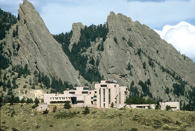
The Mesa Laboratory of the National Center for Atmospheric Research is located in Boulder, Colorado, against the backdrop of the monolithic sandstone slabs called the Flatirons.
UNIVERSITY CORPORATION FOR ATMOSPHERIC RESEARCH (CC BY-NC 4.0)
A range of missions
Among NCAR’s functions are making ground-based and airborne measurements of atmospheric chemistry, operating high-performance computing and visualization systems, and developing and supporting models and data sets for the atmospheric and geoscience research communities. The center operates two NSF-owned aircraft equipped for atmospheric measurements; has a supercomputing facility in Cheyenne, Wyoming; and manages the Mauna Loa Solar Observatory in Hawaii. Over the past two and a half fiscal years, since NCAR began tracking the statistics at the request of NSF reviewers, it has installed 59 individual measurement systems and staff members have spent around 9500 days in the field. NCAR scientists recently wrapped up participation in a six-month-long European Union–sponsored field campaign in Portugal that measured atmospheric flows over very complex terrain. The results of that campaign will inform modeling efforts and have direct applications to wind energy production, says NCAR director James Hurrell.
The NCAR open-source Community Earth System Model, developed in collaboration with universities and other research labs, helps researchers worldwide simulate past, present, and future climate. The model is updated periodically with input from an annual workshop attended by around 350 scientists. NCAR is a key partner in the multiagency Weather Research and Forecasting (WRF) Model, which guides weather forecasts nationally and globally. A research version of the WRF, based at NCAR, allows scientists to explore ways to improve the accuracy of weather forecasts. Specialized versions of the WRF have been developed for modeling atmospheric chemistry, hydrology, fires, crop conditions, and other uses.
Hurrell boasts that due to NCAR’s collaborative approach, its research publications average more citations per paper than those put out by any other geosciences institution in the world. He also takes pride in the nearly 1500 visiting scientists that came to NCAR during the past two years and in the fact that 65% of them stayed for two weeks or more.
Although recent congressional actions indicate that President Trump’s proposed 11% cut to NSF will be significantly mitigated, Hurrell says he has a plan that would manage a reduction of that scale if needed. He won’t share the plan, but he says it would not repeat the across-the-board belt-tightening that has occurred in response to the flat or reduced budgets of the past several years. “We’ve identified where our top priorities lie, and we must keep those areas strong with continued investment,” he says. Should the president’s request be enacted, “NCAR would have to reduce the scope of what it does.”
Hurrell acknowledges that morale has suffered since the budget numbers for NSF and the cuts proposed for climate and Earth sciences programs at other federal agencies became known in March. Still, he says there hasn’t been movement toward the exits. “Voluntary departures from NCAR have historically been very low,” he says. “People are committed to our mission. Boulder is a great environment, and NCAR is a great organization.”
NCAR’s programs are reviewed by an external panel of scientists every five years. NSF declined to provide the review team’s full findings, but excerpts from the 2016 report cited by Hurrell call the center’s overall scientific achievement “outstanding.” The report says, “The scientific excellence of the NCAR staff and their openness to collaborations provide significant value to the research community and promote the ability of partners in the academic, government, and private sectors to perform high quality research and develop impactful technologies.”
The review team further praised NCAR’s intellectual contributions to the advancement of observing technology and science and said the center’s supercomputing services “uniquely serve the community needs.” At the same time, the team encouraged NCAR to work toward greater diversity in its workforce and to increase its collaborations with outside researchers.
Closing the gap
Hurrell says one major research thrust at the center is to marry weather forecast models, which faithfully calculate atmospheric behavior up to 10 days ahead, with models that show how the climate will change on the order of decades to centuries into the future. “Between those, there is a huge gap in understanding the sources of predictability,” Hurrell says. For example, it’s known that the stratosphere can drive some of what happens at intermediate time scales during certain times of the year. But other such sources of predictability have yet to be discovered and tapped to make reliable forecasts on monthly, seasonal, and annual time scales.
To close the gap, says Hurrell, the numerical weather prediction and Earth system modeling communities need to work together better. He adds, “Historically they are two separate communities. We can do more to develop the modeling infrastructure so that they can utilize the same sort of tools.”
An unusual circulation that develops in the stratosphere won’t disappear in a couple of days like those in the troposphere—the layer closest to Earth—do, he says. Models that can capture the coupling of stratospheric events to the lower atmosphere will improve predictions for climate and seasonal weather.
Research applications
One of NSF’s expectations for the center is that it apply its scientific advances to meet societal needs. NCAR’s first major technology application was a system for detecting dangerous downdrafts and microbursts—known as wind shear—for airports. That work, funded primarily by the Federal Aviation Administration (FAA) and NASA, included the development of the first wind sensor and Doppler-radar-based microburst detection systems. Deployed beginning in the early 1990s, wind-shear detection systems are now in place at 110 US airports and at some international locations. William Mahoney, the interim director of NCAR’s Research Applications Laboratory, says the FAA has credited the technology with saving lives and property valued at $1 billion.
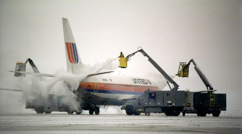
The FAA has supported multiple NCAR applications. One automated system informs pilots when the deicing solution applied to aircraft wings during wintry conditions becomes sufficiently diluted by ongoing precipitation that a second application is required. The center has produced diagnostics and prediction systems for in-flight icing; for terrain-induced, clear-air, and convective turbulence; for thunderstorms; and for visibility and ceiling conditions. Those products were transferred to the National Weather Service’s (NWS’s) Aviation Weather Center in Kansas City and are accessed by airline dispatch centers and pilots to help route commercial flights around bad weather.
Over the years NCAR has branched out to serve other customers. Last year the lab delivered to the state of Colorado an initial version of a model to predict wildfire behavior. Designed as a decision-making tool for fighting wildfires, it simulates weather conditions created by larger wildfires as they exchange heat and moisture with the atmosphere. Local winds in the area of a fire can be 10 times stronger than surrounding winds, and in rare cases, fires spawn tornadoes.
A year ago NOAA’s National Water Center in Tuscaloosa, Alabama, began using the NCAR-developed National Water Model, which couples numerical weather prediction with hydrologic models to simulate observed and forecast streamflows throughout the continental US. The tool supplements the NWS’s legacy system of 3600 river gauges used to predict flows.
“Nearly every part of the hydrologic process is physically represented in the model,” says Mahoney. Encompassing 2.7 million forecast points, the model captures land surface conditions, soil moisture, vegetation type, snowmelt, and other variables. It can provide greater advance warning of floods by spotting spikes in flow before they reach the river gauges, he says.
The lab will continue to update the model, including incorporating data from new weather and Landsat satellites when they become available. Additional development and tuning are required to take into account some physical infrastructure, such as the dams and reservoirs on managed river systems—for example, in the Missouri River basin— Mahoney says.
With support from the US Department of Transportation (USDOT), the NCAR applications lab has developed a tool to help state transportation authorities determine when to apply deicing materials and chemicals to roadways, how much to put down, and when more applications are needed. Fifteen states now use the system. A USDOT analysis showed that in its first winter of use, Indiana saved $12 million in materials and labor costs.

The Research Applications Laboratory at the National Center for Atmospheric Research has developed an aircraft deicing optimization system that lets pilots know how long their deicing fluid will remain effective.
UNIVERSITY CORPORATION FOR ATMOSPHERIC RESEARCH (CC BY-NC 4.0)
A current project for USDOT is a system to warn drivers of hazardous road conditions ahead. That system will acquire information from the onboard computers of tens of millions of vehicles—wiper settings, headlamp status, ambient air temperature, speed, location, elevation, stability control, traction control, and antilock brakes—to inform drivers of black ice, dense fog, high winds, and torrential rains.
Space weather
Researchers at NCAR are working on a seasonal forecast for when solar coronal mass ejections, which cause electromagnetic pulse (EMP) events, will likely occur, says Scott McIntosh, director of the center’s High Altitude Observatory (HAO). (See the articles by Jack Zirker and Oddbjørn Engvold on page 36 of this issue and by Gordon Holman, Physics Today, April 2012, page 56 .) Within the 11-year solar cycle, there are short-term bursts of activity that occur in approximately 11-month cycles in each hemisphere. For decades, he says, scientists have mostly ignored those excursions by over-smoothing the observational data. But if understanding of those shorter cycles can be improved, it may lead to better space weather forecasts that extend out to a year or so ahead.
“When it comes to space weather and understanding things like the Sun’s EMPs, the first we know about it, it happened eight minutes ago,” McIntosh says. “We are trying to understand when the events are going to occur to get ahead of that old paradigm.”
Scientists from the HAO will take advantage of this month’s total solar eclipse (see the Commentary by Angela Speck on page 10 of this issue) to try out recently declassified military-grade hardware for far-IR imaging. Magnetic fields can be directly measured in the longer wavelengths of the far-IR, whereas observations in the visible and near-IR parts of the spectrum require complex computer models to interpret, McIntosh says. The new IR imagers may provide the opportunity to predict the orientation of the magnetic field in a solar EMP. If oriented one way, the pulse will couple with Earth’s magnetosphere, with potentially harmful effects on communications and electricity transmission. If pointed the opposite way, the field will simply “bounce off” the magnetosphere, he notes.
McIntosh argues that a better understanding of the Sun is needed in order to understand other stars and exoplanets, but he laments that far more is spent on astrophysics than heliophysics, and only a handful of solar-physics departments exist in the US. He asks, “If we can’t understand the thing that we observe the living daylights out of, how can we hope to understand something that is 23 000 light-years away?”
More about the authors
David Kramer, dkramer@aip.org


