Global positioning: The early Finnish connection
DOI: 10.1063/PT.3.1763
Latitudes, longitudes, and distances on Earth’s surface are known today with unprecedented accuracy. But the early contributions by Finnish professor Yrjö Väisälä to today’s global positioning system (GPS) are largely unknown.
From antiquity up through most of the 20th century, mapmaking and the determination of a location’s coordinates relied on triangulation: Given a known distance along one edge of a triangle, angle measurements from the endpoints of the side allowed a person or team to calculate the coordinates of the third vertex. The larger the triangle, the more accurate are the results.
In the early 1940s, Väisälä invented and built instrumentation for elevated targets that would increase the sizes of individual triangles in triangulation networks. In his machine shop in Tuorla, Finland, Väisälä built his unique cameras for photographing flashing lights against a stellar background. His brother Vilho Väisälä manufactured the instruments that produced the flashing lights. Researchers had previously discovered that at 40 kilometers, the jet stream carried the balloons too fast over the horizon, so the Väisäläs’ flashing lights were sent up on Vilho’s weather balloons to altitudes of 20–30 kilometers. Cameras at 3 or 4 stations photographed the elevated light flashes simultaneously against each station’s star background. From the photographs, the distances and angles between the ground stations could be determined more accurately.
Yrjö Väisälä and researchers at the Finnish Geodetic Institute, including one of us (Kakkuri, the only team member still alive), were the first to successfully apply this new kind of triangulation. Test measurements were successfully performed in the 1950s. Later, in 1968–70, the national stellar triangulation network of four triangles extended over the southern part of Finland. The same area was covered earlier by about 200 terrestrial triangles.
In the 1960s and early 1970s, the US National Geodetic Survey (NGS) and the US Department of Defense (DOD) measured a satellite triangulation network covering the entire Earth. The triangulation system they used was the same one Väisälä had developed, but it used flashing lights on Earth-orbiting satellites instead of lights hanging from weather balloons. The NGS survey covered the continental US with only one triangle and yielded coordinates for the third triangle vertex that were much more accurate than those obtained by any earlier method.
In the 1980s scientists and engineers, mainly in the US, developed an even better geodetic positioning system. The new system used a trilateration method that had become possible after sufficiently precise atomic clocks were developed and deployed on the ground stations and on special Earth-orbiting satellites. The resulting system is well known as GPS, the global positioning system.

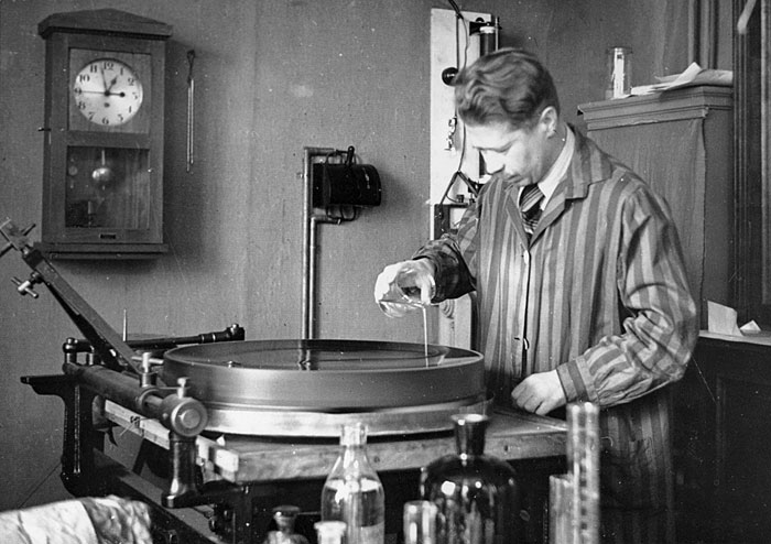
Yrjö Väisälä in the physics department’s machine shop at the University of Turku, Finland, in 1934. He is silvering the primary mirror of an anastigmatic telescope. (Courtesy of the University of Turku Central Archives.)
More about the authors
Juhani Kakkuri, (juhani.kakkuri@fgi.fi) Helsinki, Finland.
Lasse Kivioja, (lkivioja@comcast.net) Lafayette, Indiana.


