Drilling to Earth’s mantle
DOI: 10.1063/PT.3.2082
In 1909, Croatian seismologist Andrija Mohorovičić made a bold prediction—that Earth consists of distinct layers of rock above its core. On analyzing an earthquake that had struck earlier that year, he noticed that seismic waves below a depth of about 56 km travel a few kilometers per second faster than those above that depth. The abrupt change in speed marks what is now known as the Mohorovičić discontinuity, or Moho—the boundary between Earth’s crust and upper mantle, where a fundamental change in the rocks’ composition is thought to occur. Below the continents, the Moho’s depth can vary from 25 km to 60 km. But underneath the oceans the crust is much thinner, and the Moho lies tantalizingly close to the sea floor—typically just 6 km below it.
In 1957 a group of American geoscientists led by Harry Hess, a founder of the theory of plate tectonics, proposed an ocean drilling program dubbed Project Mohole designed to sample a section of crust and shallow mantle to understand its composition, structure, and evolution. Four years later, between March and April 1961, the team successfully recovered a 14-m-long core of hard, oceanic crust, or “basement,” off the coast of Guadalupe, Mexico, below 3600 m of water and 170 m of sediment. 1
That demonstration, though, was the extent of the original project’s achievement. Ocean drilling for petroleum was in its infancy at the time. Dynamic positioning, a technology to stabilize the position of a ship during the drilling process, didn’t yet exist, and Project Mohole lost its funding in 1966. The Apollo program, begun almost the same time as Mohole, recovered lunar samples within a decade, yet despite a half century of undersea drilling, no one has yet managed to reach the Moho.
Nonetheless, Project Mohole led to the establishment of an international collaboration in scientific ocean drilling that has continued for decades. The collaboration is currently known as the Integrated Ocean Drilling Program (IODP); after October 2013 it will be known as the International Ocean Discovery Program. And with the recent development of the Japanese vessel Chikyu, briefly described in box
Mohole to mantle
Much of the crust–mantle dynamics is understood. The thin rocky ocean crust that covers almost two- thirds of Earth’s surface forms out of magma, partially melted mantle rock extruded at the mid-ocean ridge, the world’s longest volcanic chain. Along that chain, which wraps around the planet like the seam of a baseball for more than 65 000 km, the tectonic plates are continually renewed by the solidified magma as they gradually move apart. The rate at which they spread depends on a plate’s location and varies from less than 1 cm/yr to as much as 17 cm/yr. Although only a fifth of the plates in today’s mid-ocean ridge spread quickly—at more than 8 cm/yr—more than half of today’s sea floor, and the great majority of crust subducted back into the mantle during the past 200 million years, was produced at those fast-spreading parts of the ridge.
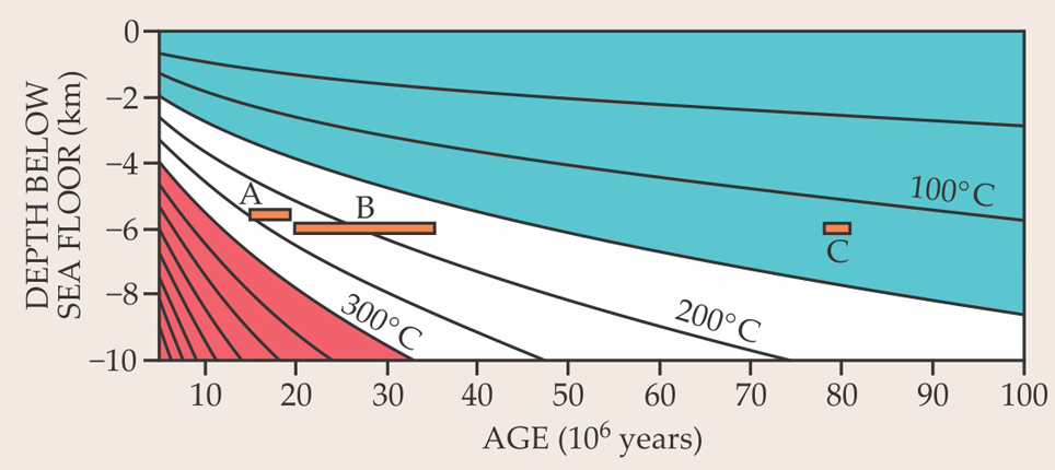
As a plate moves away from the ridge, it cools predictably with age, as outlined in figure 1. In addition, seawater enters the crust and uppermost mantle through deep fractures, where it is heated and becomes a reactive fluid that hydrates surrounding rock and exchanges materials with it before returning to the ocean. While chemically altered by the fluid, the crust and uppermost mantle may also become a habitat for microorganisms. Elsewhere, subducting plates drag seawater into the mantle, where the water reduces rock viscosity and melting temperature (see the article by Marc Hirschmann and David Kohlstedt in Physics Today, March 2012, page 40 ).

Figure 1. Oceanic crust forms at the mid-ocean ridge and slowly cools as it ages and moves away from the ridge. A simple thermal diffusion model predicts the temperature of the crust and upper mantle as a function of age and depth below the sea floor. Applying appropriate boundary conditions—a thermal diffusivity of 6 × 10⁻⁷ m2 s−1, an initial mantle melting temperature of 1340 °C, and a sea-floor temperature of 0 °C—yields the isotherms shown in the plot. The orange bars indicate the approximate temperature at each of the prospective drilling regions—A (the Cocos plate), B (off Baja, California), and C (off Hawaii), discussed in box
Like water, carbon is an essential material for life, and both play critical roles in Earth’s environment. But our knowledge of the contribution of the mantle, the largest reservoir of both components, to the global water and carbon budgets remains totally unconstrained in the absence of representative samples. “Representative” is the operative word. Indeed, one can argue that samples from Earth’s mantle are not rare. But they reach the surface heavily altered from their original, pristine state underground.
Pieces of mantle may be entrained in the upward flow of buoyant magma and brought to the surface during volcanic eruptions or spliced into the continental crust during the collisions of continents. Those mantle rocks may have lost part of their original composition through melting. They may have become part of tectonically uplifted outcroppings that now lie exposed on the sea floor or one of Earth’s continents; extremely large sections of displaced crust and mantle known as ophiolite exist in a few places around the world and are heavily studied, partly because they’re so easily accessible. Those slices through ancient Moho are thought to preserve a record of the melting and crystallization process similar to what occurs at the mid-ocean ridge (see Physics Today, January 2005, page 21 ), but because of their violent history, no one knows where or how deep underground they came from.
A few kilograms of fresh mantle from beneath an intact, tectonically quiet region of oceanic crust would provide a wealth of new information, comparable to the treasure trove obtained from the Apollo lunar samples, on Earth’s dynamics and evolution. That’s a central motivation driving the new Mohole to the Mantle (M2M) project.
Because of the relatively uniform architecture of fast-spreading plates, understanding the genesis and evolution of crust and mantle at one site can be extrapolated with some confidence to much of Earth’s surface. Earth scientists have well-developed theoretical models of ways in which magma accretes along ridges and becomes crystallized rock, and such models can be tested using samples recovered from cored sections of ocean basement.
Besides testing the models of crustal accretion and melt movement, the drilled cores will be used to resolve the geometry and intensity of the circulation of hot water in underground fractures and subduction zones and to document the limits and activities of the deep microbial biosphere. After the hole is drilled, the several-kilometer-long tube of crust and mantle removed, and the painstaking process of logging the data completed, the hole will be used for additional experiments. Sensors and other subsea equipment will be installed in the borehole to monitor physical stresses, fluid movement, temperature, and pressure.
The mantle’s makeup
Earth comprises distinct chemical reservoirs. The deepest is the core, which, constituting just under a third of the planet’s mass, is metallic and thought to consist mostly of iron. Above it resides the voluminous mantle, which contains some two-thirds of Earth’s mass in three principal layers of rocky, silicate materials. The overlying continental and oceanic crusts, by comparison, contain less than 1% of Earth’s mass and are themselves composed of solidified magma. A better grasp of the mantle’s composition would enable researchers to place better constraints on melting processes. It would also help determine the nature of Earth’s asteroidal building blocks and the time scales and physical conditions at which they accreted to form the planet.
Current estimates of the chemical composition of the silicate part of Earth come from mantle samples delivered to the surface. Those “peridotites,” which contain about 75% olivine [(Mg, Fe)2SiO4] and lesser amounts of other silicates and oxides, vary in composition by virtue of being tectonically altered, partially melted, or possibly infiltrated with melt from other types of rock. Mantle peridotite typically begins to melt at about 1300 °C and is completely molten by 1700 °C, depending on pressure. At mid-ocean ridges, about 15% of the mantle melts and produces the volcanic rocks of the ocean floor. The residual mantle left behind is depleted of “incompatible” elements—those elements in the rock that melt most easily.
It’s long been recognized that silicate Earth’s composition can be approximated as some combination of residual peridotite and the silicate melts that form crustal rock. 3 Ocean drilling offers a way to improve our understanding of the relationship between those two components. Currently, the best estimate of “primitive” unmelted mantle comes from peridotites that show the least evidence of having undergone partial melting. 4 Such mantle pieces and others whose unmelted compositions are theoretically reconstructed appear to contain certain elements in identical abundance ratios to so-called chondritic meteorites and the Sun.
The elements of concern are the lithophilic (rock-loving) elements such as calcium, aluminum, titanium, uranium, and scandium, which remain concentrated in the silicate part of Earth. By contrast, the mantle is depleted in siderophilic (iron-loving) elements such as nickel, cobalt, platinum, and gold, which were swept into the core as the planet differentiated. A direct demonstration that the mantle contains precisely chondritic ratios of some elements and deviates from that model ratio in others is likely to have powerful implications for our understanding of planetary accretion and differentiation and the timing of those events in Earth’s geological history. (See the article by Bernard Wood, Physics Today, December 2011, page 40 .)
Currently geologists have no viable alternative to the chondritic-Earth assumption. But in 2006, Maud Boyet and Richard Carlson suggested that the assumption breaks down, at least in the case of the samarium–neodymium abundance ratio in the primitive mantle. 5 Their thesis, it’s been argued, 6 may indicate that an early formed crust was lost to space by the bombardment of meteors early in Earth’s history. If our current chondritic-ratio models are crude and wrong in detail, a central question becomes, Exactly how wrong? Pristine samples recovered by ocean drilling should help answer that question.
Meaning of the Moho
Because the vast majority of Earth’s deep interior is inaccessible by direct sampling, our understanding of its layered structure is indirect, based largely on seismic models that are calibrated using high-temperature and high-pressure experiments on mantle-borne materials.
Fast-spreading oceanic crust is seismically divided into three layers, shown in figure 2, each of which varies in the speed Vp at which compressional waves propagate through it. Seismic waves travel at less than 3 km/s through the top layer, which is commonly interpreted as fine-grained sediment. In the second and third layers, respectively, the wave speed increases up to 6.7 km/s and then levels off around 7 km/s. In those two layers, the waves pass from lavas and sheeted dikes—essentially vertical intrusions of solidified magma, or basalt—and into “gabbro,” a coarse-grained and crystalline form of basalt rich in low-density aluminum.

Figure 2. When a seismic wave encounters an interface between materials with different acoustic impedances, some of the wave’s energy is reflected. At left, a seismic reflection image shows the layered structure of crust beneath the Pacific Ocean. At its right are compression-wave velocity profiles Vp of the seismic waves propagating through the layers, with zero depth referenced to the bottom of the first, sedimentary layer. The sharp, strong reflection below the third layer marks the Mohorovičić discontinuity, or Moho, the boundary between Earth’s crust and its lithosphere, or upper mantle. In the plot, the gray region outlines the range of seismic velocity profiles measured through 29-million-year-old crust of partially melted mantle rock extruded from Earth’s mid-ocean ridge. The green and red profiles are the estimated wave velocities around holes at drilling sites 1256 (described in box
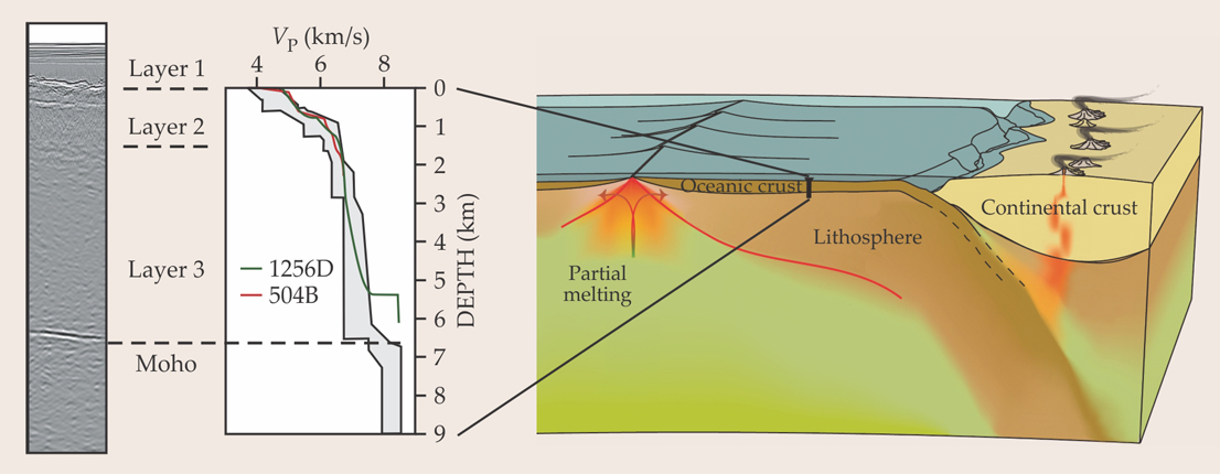
Previous drilling expeditions to the hole dubbed 1256D, at one of the prospective sites for the M2M project (see box
Just below the third layer is the Moho, marked by a sharp velocity transition from about 7 km/s to 8 km/s that occurs within 500 m. It is the outermost seismic boundary separating crust and mantle, and its geological meaning will remain a matter of conjecture until core samples are collected. But because the seismic transition is sharp, the discontinuity is thought to represent the geological contact between gabbro and the peridotites, which are more dense, being rich in magnesium and poor in aluminum.
In other places the Moho may be a more diffuse, complex transition zone with numerous seismic reflecting layers, 9 as seen in parts of the Oman ophiolite. 10 Recent seismic data in the western Pacific reveal a particularly high compression-wave velocity of 8.6 km/s and strong anisotropy with respect to direction of the waves immediately below sharply imaged Moho. Those data, from Shuichi Kodaira (Japan Agency for Marine-Earth Science and Technology) and colleagues, seem to suggest that the reflectors sit in a preferred orientation relative to the mid-ocean ridge axis; that orientation is produced by inhomogeneous stresses or shearing. The orientation could be detected in drill cores and would help answer a fundamental question in geodynamics: whether the upwelling path of hot deep mantle material is best modeled as a passive, plate-driven flow or an active, buoyancy-driven flow.
A biological perspective
To a biologist, the M2M project presents several interesting issues: defining the limits of life, identifying signatures of present or past life, and learning what new types of metabolism may be required for organisms to grow and survive. Let’s take each issue in turn.
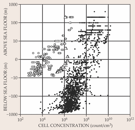
The limits of life. What are the extremes of temperature, pressure, and nutrient depletion to which earthly life can adapt? As one proceeds downward from sea-floor sediment toward the Moho, when do the conditions become so extreme that life is no longer detectable in recovered drill-core samples? Current evidence from a number of different laboratories indicates that microbial life, as tough as it is, disappears rather rapidly with sediment depth: 11 Few recognizable biological cells remain intact at depths of 2 km or more below the sea floor. (For a 2009 plot of the available data, see figure 3.)

Figure 3. Microbial cells, whose number is determined by fluorescent imaging, decrease in concentration with depth in sea-floor sediment. Open circles represent cells found below the South Pacific Gyre, where cell numbers are very low even at the sea-floor surface thanks to the nutrient-poor nature of the gyre. Open triangles represent cells found at the edges of the gyre, where more organic-compound-enriched sediments exist on the sea floor; filled circles represent cells found in sediments elsewhere on the Pacific sea floor. The cellular concentration decreases roughly linearly to very low levels—about a factor of 10 or more for each order of magnitude increase in depth below the sediment surface. (Adapted from ref.
Evidence from nearly 40 years of studying thermophilic microbes indicates that they are capable of growth up to about 115 °C, a temperature that corresponds to depths of 4 km to 5 km below the sea floor. 12 Temperatures at which cellular life could survive may be much hotter than that, though. Fifty years ago no one would have believed that life could survive, let alone thrive, at 100 °C, the temperature of many thermophile communities along the edges of hot vents in the deep ocean. What’s more, although details provided by drill-core samples cannot help but be specific to Earth’s crust, the findings may shed light on life-detection missions on other planets or other extreme environments on Earth.
The search for biomolecules. Retrieved samples should offer ample information about conditions in which biomolecules, both organic and inorganic, survive or are destroyed past the point of recognition. Life is surprisingly resilient, and ways that it or its chemistry survives extreme conditions belowground will be of great interest. That may be especially true for inorganic metal isotopes—one of our best tools for the study of ancient life—which may offer new clues to early life far below where organic molecules are stable.
New types of metabolism. What kinds of energy sources, both organic and inorganic, are available in deep sediment and crust? It’s generally thought that subsurface metabolism is predominantly lithotrophic—powered by inorganic energy sources, typically hydrogen in the subsurface (for a discussion, see reference ). Actually, almost any chemical capable of serving as a source of electrons can, in principle, be used by life, and thus may have somehow influenced or driven the origin and evolution of life. And understanding where deep subsurface biota reside should provide insight into where some of the earliest life on our planet may have been harbored. As with the search for life beyond Earth, one can’t be sure that life in the deep unknown will conform to our definition of life at the surface, but it should prove fascinating to ply so-called non-Earth-centric methods that can detect life even if it turns out to be fundamentally different from forms with which we’re familiar. 14
Almost nothing can be said with certainty other than at some depth belowground, conditions become so severe that carbon–carbon bonds become unstable and life as we know it disappears. And although it’s not clear what will be learned, we’ll almost certainly gain a new appreciation of many aspects of life above the surface through an analysis of what’s below it.
The optimism of Harry Hess is worth applying to the M2M project more generally. As he said at a US National Academy of Sciences meeting in 1958:
Perhaps it is true that we won’t find out as much about the Earth’s interior from one hole as we hope. To those who raise that objection I say, If there is not a first hole, there cannot be a second or a tenth or a hundredth hole. We must make a beginning.
Perhaps it is true that we won’t find out as much about the Earth’s interior from one hole as we hope. To those who raise that objection I say, If there is not a first hole, there cannot be a second or a tenth or a hundredth hole. We must make a beginning.
Fortunately, because of the petroleum industry’s efforts to mine oil offshore, there exist a well-established infrastructure and history of hole drilling. The scientific quest is to go deeper and bring up what will hopefully be treasure troves.
Box 1. The challenge and the Chikyu
The deepest hole ever drilled, on the Kola Peninsula in Russia, reaches 12.3 km underground. But under the sea floor, a more challenging environment in which to drill, few holes exceed a kilometer; to date, the record is 2.1 km at the Integrated Ocean Drilling Program (IODP) site 504. The technology required to go deeper is feasible.
A hole more than a few kilometers deep tends to collapse during drilling, under the huge load from Earth’s crust around it; the pressure difference between crustal rock and the water column on a hole 3 km deep is 45 MPa. To prevent or forestall the collapse, engineers circulate drilling mud through what’s known as a riser system that connects the borehole with an onboard pump. One steel outer pipe surrounds an inner one, the drill “string” through which a “core” is recovered. The mud and drill shavings are pumped up to the ship in the space between the two pipes. With a density between seawater and the rock surrounding the hole, the circulating mud reinforces the walls of the hole and acts as a lubricating fluid.
The deep-sea drilling vessel Chikyu (“Earth” in Japanese), shown here, was designed to reach down to about 7.5 km under the sea floor and was launched in 2002. Although it’s currently equipped with a riser system that can operate at ocean depths of 2.5 km, work is under way to develop the technology required to drill in ocean depths exceeding 4 km, where the crust is coolest. (For more on IODP’s drilling activities, see the report on page 22 .)

Other aspects of the project also require further engineering. Strategies are needed for coring and logging rock samples at temperatures near 250 °C, the hottest temperature at which drilling equipment remains durable (coring refers to retrieving the cylindrical rock samples, and logging refers to the recording of information, both as drilling proceeds and after the core has been retrieved). Drill bits that can effectively cut hard, abrasive, hot rock at the end of high-tensile-strength drill strings will also be essential. So will low-weight drilling mud, casing, and cementing materials that work in hot conditions.
When sampling the rock retrieved from the Moho, researchers will no doubt be confronted with unprecedented challenges, such as precisely discerning what distinguishes living and dead cells in anaerobic, high-pressure, high-temperature regions and discriminating microflora from contaminants. Both require creative and innovative solutions.
Box 2. Drilling site selection

Ideally, researchers would prefer to drill in the shallowest water that overlies the coldest oceanic crust. But those are conflicting requirements: In shallow water, close to the mid-ocean ridge, the crust is young and hot; farther from the ridge, it’s older and colder, but under deep water (see figure 1). Prospective drilling sites for the Mohole to the Mantle Project are limited to three candidates, all in the Pacific Ocean: the original late-1950s drilling site off the coast of southern California; Ocean Drilling Program (ODP) site 1256 on the Cocos plate off the coast of Mexico; and a site just north of Hawaii.
Crust that is older than 20 million years should meet the temperature requirement, with crust cooler than about 250 °C at Mohorovičić-discontinuity depths. The area on the Cocos plate is advantageous in that it sits in the shallowest water and over the thinnest crust. But that crust is also warmer than 250 °C at the Moho; major obstacles posed by the high temperature include thermal shock on the rock to be drilled and the durability of logging tools. The Baja site contains older crust, 25 million to 35 million years old, and is cooler than 250 °C at the Moho, but that site lacks modern seismic data needed to evaluate Moho characteristics. Finally, the site off Hawaii is oldest and thus coldest, but it’s also in the deepest water. In addition, the influence of arc volcanism and the Hawaiian plume on the crust and mantle there remains uncertain (see the article by Eugene Humphreys and Brandon Schmandt, Physics Today, August 2011, page 34 ).
References
1. For a personal account, see J. Steinbeck, Life, 14 April 1961, p. 110.
2. M. Bickle et al., Illuminating Earth’s Past, Present, and Future: The Science Plan for the International Ocean Discovery Program 2013–2023, Integrated Ocean Drilling Program Management International, Washington, DC (2011).
3. A. E. Ringwood, Geochim. Cosmochim. Acta 15, 257 (1959). https://doi.org/10.1016/0016-7037(59)90062-6
4. S. R. Hart, A. Zindler, Chem. Geol. 57, 247 (1986); https://doi.org/10.1016/0009-2541(86)90053-7
W. F. McDonough, S. S. Sun, Chem. Geol. 120, 223 (1995). https://doi.org/10.1016/0009-2541(94)00140-45. M. Boyet, R. W. Carlson, Earth Planet. Sci. Lett. 250, 254 (2006). https://doi.org/10.1016/j.epsl.2006.07.046
6. I. H. Campbell, H. St. C. O’Neill, Nature 483, 553 (2012). https://doi.org/10.1038/nature10901
7. D. A. H. Teagle et al., Proc. Integrated Ocean Drilling Program, vol. 335, IODP Management International, Tokyo (2012).
8. D. S. Wilson et al., Science 312, 1016 (2006). https://doi.org/10.1126/science.1126090
9. M. R. Nedimović et al., Nature 436, 1149 (2005). https://doi.org/10.1038/nature03944
10. N. Akizawa, S. Arai, A. Tamura, Contrib. Mineral. Petrol. 164, 601 (2012). https://doi.org/10.1007/s00410-012-0762-4
11. S. D’Hondt et al., Proc. Natl. Acad. Sci. USA 106, 11651 (2009). https://doi.org/10.1073/pnas.0811793106
12. M. T. Madigan et al., Brock Biology of Microorganisms, 13th ed., Benjamin Cummings, San Francisco (2012).
13. K. J. Edwards, K. Becker, F. Colwell, Annu. Rev. Earth Planet. Sci. 40, 551 (2012). https://doi.org/10.1146/annurev-earth-042711-105500
14. P. G. Conrad, K. H. Nealson, Astrobiology 1, 15 (2001). https://doi.org/10.1089/153110701750137396
More about the authors
Susumu Umino is a petrologist at Kanazawa University in Japan, Ken Nealson is a microbiologist at the University of Southern California in Los Angeles, and Bernard Wood is a geochemist at the University of Oxford in the UK. All are research professors.


