The tsunami triggered by the Chicxulub impact
DOI: 10.1063/pt.htyz.zmzd


An asteroid struck the ocean’s continental shelf near the modern-day Mexican town of Chicxulub some 66 million years ago. The collision energy was 3 × 10²³ J, which is equivalent to about 5 billion Hiroshima-sized atomic bomb explosions. Within seconds, the impact excavated a hole more than 20 km deep into Earth’s surface and threw bedrock and sediment into the upper atmosphere.
As impact ejecta fell back to Earth, the heat from their reentry generated a global pulse of thermal radiation similar to the conditions of an oven set on broil for about one hour. The thermal radiant flux and hot falling ejecta ignited widespread forest fires. The resulting soot blocked sunlight for several years, and the ensuing frigid surface temperatures led to widespread plant die-offs and the demise of a vast array of animals. Approximately 75% of species, most famously the non-avian dinosaurs, went extinct shortly after impact. Other life forms, including mammals and flowering plants, reemerged as dominant species.
Scientists in the 1980s and 1990s pinpointed the crater location from anomalies in Earth’s gravity and magnetic fields. More recently, measurements from drill cores corroborated the basic conclusions of crater-formation models. They also suggested that the impact could have triggered a powerful tsunami. Motivated by that possibility, the three of us and several colleagues asked whether such a tsunami could have had global effects. In 2022 we published the first global simulation of the Chicxulub megatsunami.
The first 10 minutes after the initial impact and the tsunami’s formation were simulated with a shock-physics model that’s widely used to study crater formation on Earth and other bodies in the solar system. The results of that model were then fed into propagation models to track the tsunami across the globe for two days. Finally, we examined geological records for evidence of global tsunami propagation.
Simulating the impact
The cavity formed by the impact was initially 28 km deep, but under the force of gravity, it collapsed into a crater roughly 3 km deep. As the crater took shape, a curtain of ejecta pushed water outward and initiated the advancing rim wave, shown in blue in figure
Figure 1.

The Chicxulub impact 66 million years ago displaced crustal material (brown) and sediments (yellow) and launched a tsunami that spread around the globe. The origin marks the point of impact. A curtain of ejected sediment, tens of kilometers high, pushed ocean water outward to form a rim wave (blue) that was 4.5-km-high about 2.5 minutes after impact and traversed Earth’s oceans.
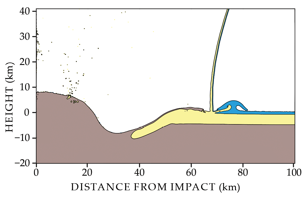
Today’s large tsunamis are simulated with shallow-water wave models, which assume that a tsunami’s wavelength is much greater than the ocean depth. The water in the Gulf of Mexico, close to where the Chicxulub tsunami originated, deepens rapidly. The exact depth of the ocean 66 million years ago, however, is highly uncertain. But regardless of what the water depth may have been then, the model’s results were about the same for all simulations, in which the depths ranged from 1000 to 3000 m. The tsunami for each simulation evolved into a 100-km-long wave—enough to satisfy the shallow-water assumption—10 minutes after impact.
Figure
Figure 2.

The wave created by the dinosaur-killing asteroid impact made its way to most of the world’s oceans. Colors indicate the maximum amplitude of the Chicxulub tsunami around the locations of ancient continents (gray), with the location of today’s continents outlined in black for reference. Open-ocean tsunami amplitudes were highest in the Gulf of Mexico, the Caribbean Sea, and the North Atlantic and South Pacific Oceans.
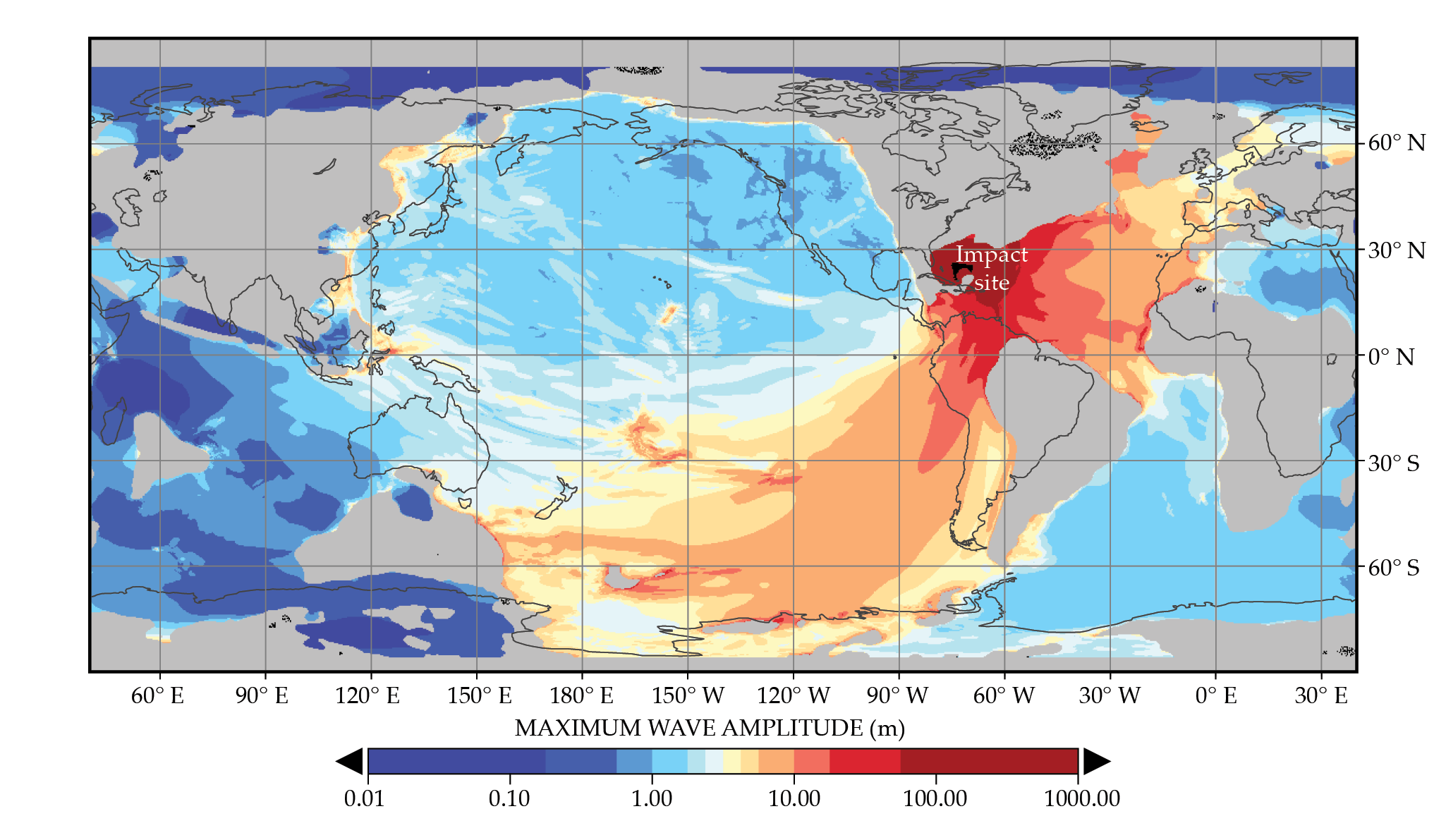
Because the Chicxulub impact took place 66 million years ago, Earth’s continents and mid-ocean ridges were in different locations than they are today. To capture the tsunami’s evolution, we used an ocean basin map with boundaries that were drawn by plate tectonics experts. The land bridge between North America and South America, for example, was absent, so the propagating tsunami wave easily entered the Pacific Ocean.
Connecting the geological record
According to figure
To assess how realistic the simulation results may be, we compared them with sedimentary records located throughout the globe on land and in the open ocean. Open-ocean sediment cores are obtained with ocean drilling vessels that use the same technologies as oil drilling rigs. The deeper one looks into a sedimentary record, the further one travels back in time: The individual layers of rock can be dated through measurements of radioactive isotopes.
Consistent with the tsunami model results, sediment cores from 66 million years ago suggest that erosion was substantial in the Gulf of Mexico, the Caribbean, the North Atlantic, and the South Pacific. Sediments appear to be less eroded where the tsunami model predicts weak velocities, including in the Mediterranean Sea and the South Atlantic and North Pacific ocean basins.
We are already working on a follow-up study in which we simulate the coastal flooding caused by the tsunami. We are using estimates of land elevations and revised representations of continental geometries that take into account more geological data, especially near the impact site and in selected far-field regions that experienced large tsunami wave heights and high velocities. A new simulation that incorporates the detailed physics of coastal flooding should allow for a closer comparison between model results and geological records from the open ocean and coastal areas.
Brian Arbic thanks NSF and its Research Experiences for Undergraduates program for funding the work of Molly Range, an undergraduate student, on the project. Brandon Johnson thanks the developers of the iSALE shock-physics code. Vasily Titov acknowledges support for the work from NOAA, contribution number 5533.
References
► M. M. Range et al., “The Chicxulub impact produced a powerful global tsunami,” AGU Adv. 3, e2021AV000627 (2022). https://doi.org/10.1029/2021AV000627
► J. Erickson, “Dinosaur-killing asteroid triggered global tsunami that scoured seafloor thousands of miles from impact site,” Michigan News (4 October 2022).
► C. G. Bardeen et al., “On transient climate change at the Cretaceous−Paleogene boundary due to atmospheric soot injections,” Proc. Natl. Acad. Sci. USA 114, E7415 (2017). https://doi.org/10.1073/pnas.1708980114
► J. V. Morgan et al., “The formation of peak rings in large impact craters,” Science 354, 878 (2016). https://doi.org/10.1126/science.aah6561
► H. J. Melosh et al., “Ignition of global wildfires at the Cretaceous/Tertiary boundary,” Nature 343, 251 (1990). https://doi.org/10.1038/343251a0
► L. W. Alvarez et al., “Extraterrestrial cause for the Cretaceous–Tertiary extinction,” Science 208, 1095 (1980). https://doi.org/10.1126/science.208.4448.1095
More about the authors
Brian Arbic is a professor of physical oceanography at the University of Michigan in Ann Arbor. Brandon Johnson is a professor of geophysics and planetary sciences at Purdue University in West Lafayette, Indiana. Vasily Titov is chief scientist at the NOAA Center for Tsunami Research in Seattle, Washington.


